
Mexico, Part 1: CDMX and its Neighboring Cities & Towns
I’ve traveled throughout many parts of Mexico since 2015, but this blog is more of a culmination of my favorite places within a few hours of Mexico City. However, these particular visits occurred in late 2024. My Spanish tutor and good friend, Erick Fabila, who currently lives in CDMX, helped me choose and navigate many of these locations.
Table of Contents:
The Basics
Within a Few Hours Southwest of CDMX: Tepoztlan, Tlayacapan and Nevado de Toluca
Within a Few Hours North of CDMX: Queretaro, Pena de Bernal, The Sierra Gorda and Guanajuato
Within a Few Hours East of CDMX: Val’ Quirico, Cholula, Puebla, Atlixco, Mineral del Chico and Parque Nacional Iztaccihuatl
Mexico City (CDMX): Polanco-Condesa-Roma, Centro Historico, Teotihuacan Pyramids, Ecatepec and Xochimilco
The Basics
Border Entry: A valid passport is all that’s required to enter Mexico.
Vaccines: No mandatory vaccines are required to enter Mexico. Additionally, CDMX and its surrounding areas are not disease risk zones.
Best Time of Year to Visit: The overall best time to visit Mexico City and its surrounding areas is during the Spring (March to May). This period offers the most pleasant weather--warm, sunny days and cool evenings--before the heavy afternoon rains of the summer begin. This is also Jacaranda season, when the city's streets are covered in vibrant purple blossoms. It is widely considered the most photogenic time to visit. In my opinion, the second-best time of year is Fall (October-November) because you can witness the massive Day of the Dead celebrations.
Visit Duration: Assuming you’re in full vacation mode and not working, you'd need 2-3 weeks to cover all of the destinations below. Unlike some other blog destinations, planning extra days for inclement weather isn't necessary because rain is rare.
Weather & Altitude: As mentioned above, the weather is predominantly sunny, ranging from 60 to 80 degrees during the Spring time. You might encounter colder weather on some of the higher altitude hikes, so bring heavier clothing to be safe. Mexico City sits at 7,500 feet so there is a possibility of altitude sickness or fatigue, but I was completely fine.
Accommodations:
Mexico City: The three most popular tourist zones are Polanco, Condesa and Roma with Polanco being the most expensive and safest. However all three are a quick Uber ride away from each other--walking is also an option. I would recommend staying in Polanco for any first time visitors because it has the most restaurants, shopping, and is the most lively. I spent half the time at the W Hotel and the other half at an Airbnb called Lamartine 619 Residencial, both locations were in Polanco, central to all the action. Condesa was my second favorite because it had an older, classier and more local vibe, filled with boutique coffee shops and restaurant options.
Within a Few Hours of CDMX: I'm sure that you can find Airbnb's in most of the cities and towns covered below. However, I chose to book mostly hotels because it was easier to do on the fly, the locations seemed more centralized and I wanted to ask for recommendations on things. Plus, Airbnb's instructions can become overwhelming, especially for a one- or two-day stay.
Costs: Mexico City is generally considered affordable for travelers, especially compared to major US or European cities. While street food and metro rides are very cheap ($.25- $3 USD), costs can rise in the trendier neighborhoods. Costs should be even more affordable in the surrounding cities and towns.
Transportation:
Renting a Car: Organized tours cover several of the destinations in this blog, but renting a car is significantly more economical. Working on your own time will allow you to see and do more without returning to CDMX for the next activity. A basic midsize four-door car is perfect for these excursions.
Rideshare Apps: In CDMX, Uber is generally considered the most reliable and widely used, while DiDi is frequently cited as the cheaper alternative. However, options could be much more limited outside of Mexico City.
Metro: Although I didn't use it much, CDMX has a very large metro system consisting of a subway, buses and cable cars. I used the cable cars more for sightseeing than for actual transportation.
Groceries: You'll find many small markets all over Mexico City, but one of the reasons for staying in Polanco was that it offered the healthiest and most abundant options. A few CDMX options are listed below, but you might only find Chedraui and Walmart in other cities.
Chedraui: This chain operates a massive network of over 500 stores across Mexico under several formats tailored to different budgets and shopping needs. Polanco has the "Selecto" store which is more premium and up-scale. Chedraui stores are typically considered "mega stores," offering a wide range of products similar to Target.
City Market: Considered Mexico's most ultra-premium, gourmet grocery experience, similar to Whole Foods--they even offer a food-bar station. For the record, I shopped here more than anywhere else.
Walmart: Believe it or not, Walmart is considered the absolute giant of Mexican retail. Although City Market and Chedraui dominate premium products, Walmart dominates by covering every possible budget through its four distinct store formats.
El Palacio de Hierro: Also located in Polanco, this is Mexico's premier luxury department store chain and widely recognized as the most upscale retailer in the country. The mall offers high-end amenities such as gourmet food halls and fine-dining restaurants which is another great option to keep in mind.
Fitness Centers: In Polanco, many hotels, such as the W and Airbnbs have nice on-premise gyms. However, there might be fewer options in Condesa and Roma. If you prefer visiting a larger location in Polanco, I recommend SmartFit because of its centralized location, affordability, and large facility--think 24 Hour Fitness. You can also find more boutique studios like Orange Theory and F45, and other yoga spots by searching more carefully. Fitness options are definitely much more limited outside CDMX so you might want to purchase a few weights at Chedraui depending on your length of stay.
Wi-Fi: Connections are solid in most of Mexico City and surrounding areas with the exception of the day hikes.
Wildlife: Most, if not all, of these excursions won't provide the opportunity to see exotic wildlife not already in the United States. Deer, rabbits, foxes, coyotes, monarch butterflies and numerous bird species are all to be expected. Pumas and a small population of black bears live in a few of these areas, such as the Sierra Gorda, but they are nearly impossible to see.
Random Thoughts:
As I say in most blogs, always try to book anything that can be impacted by weather earlier in the trip. That way, you can always reschedule the activity to another day if needed. Similarly, have backup options ready for those activities that might get canceled. However, the dry and sunny climate means there is a low chance of cancellations.
I found this interesting: Mexico City is often referred to as "Mexico," especially on the highways. You'll also hear "CDMX."
The rest of the blog is separated into four sections: Mexico City, and areas a few hours north, east, and southwest of the city. You might wonder why Mexico City isn’t first in the blog, but that's because most of my best photos and experiences occurred outside the city. There really isn't a "correct" order to plan your itinerary, but breaking it into different regions worked out well.
Within a Few Hours Southwest of CDMX
The following locations are all within a 2-to-3-hour drive of Mexico City.
Tepoztlan
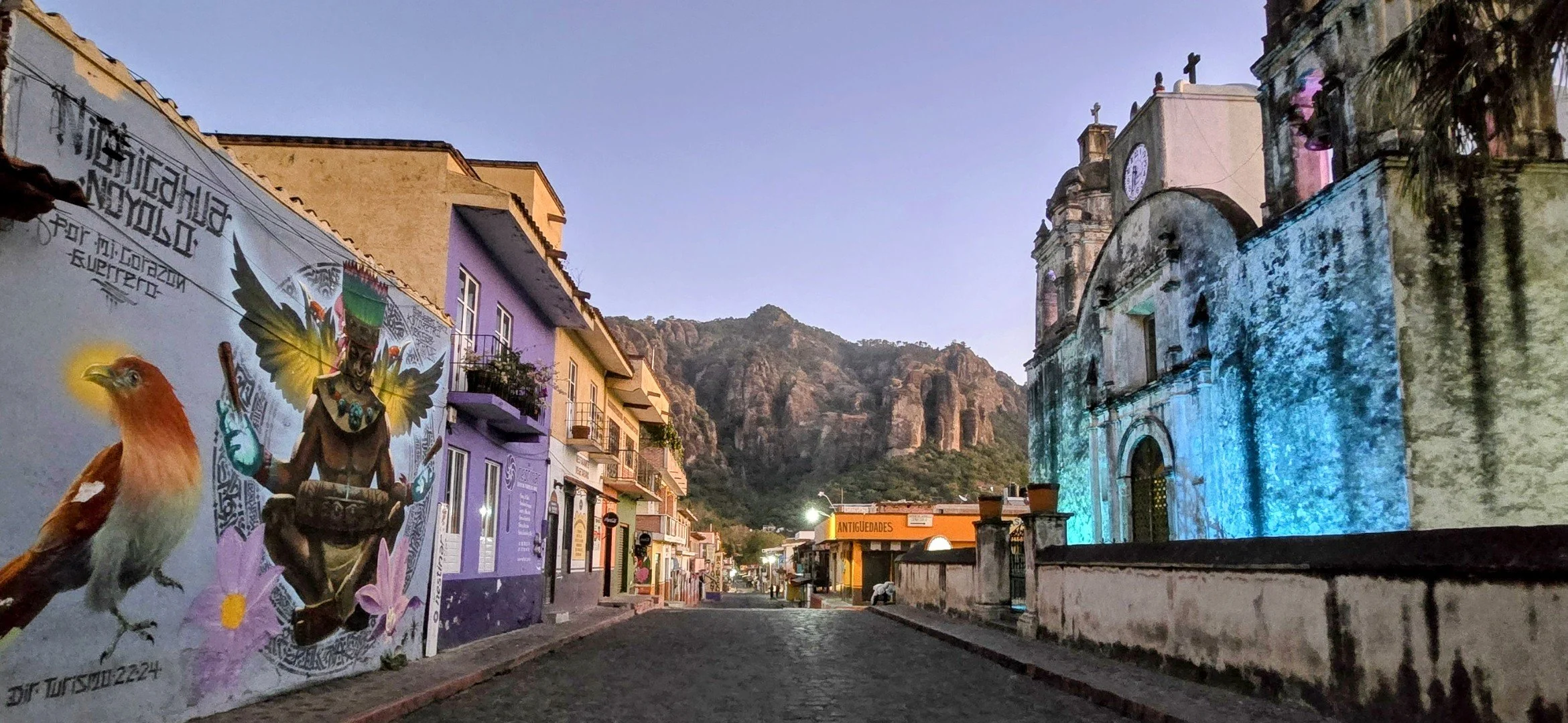
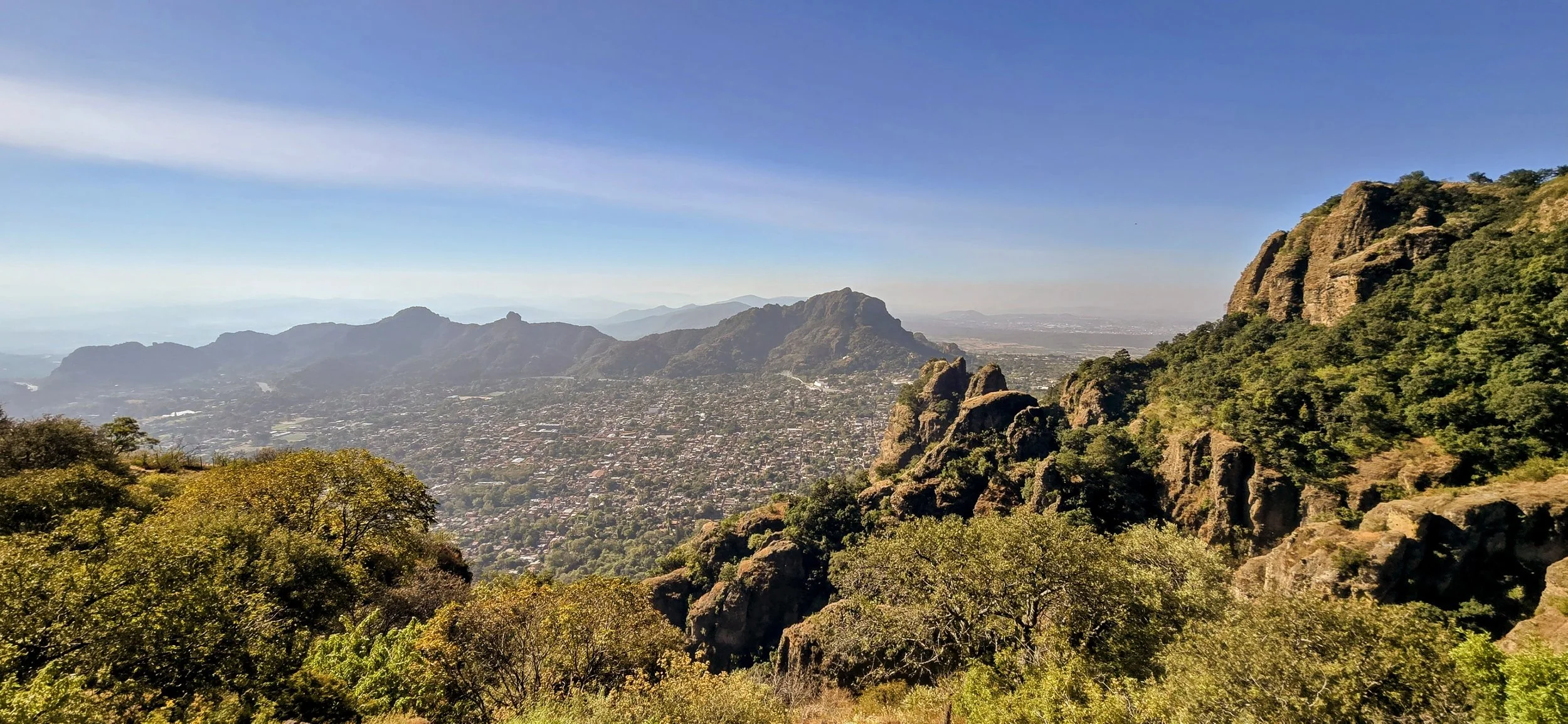
Tepoztlán was one of my favorite Pueblo Magico's in Mexico because it's a nature and hiker's paradise, nestled at the base of dramatic jagged cliffs and lush scenery. Still under the radar for most American and European tourists, it's a popular local weekend retreat known for its deep spiritual energy and ancient Aztec history. I've never been to Tulum and have no desire to go (lol), but I'd imagine Tepoztlan shares similar vibes. It's a short 90 minute drive south from CDMX. You can Uber there but you'll need a taxi to return to the city. I recommend staying in Tepoztlán for three days because there are other nearby adventures that await. This photo was taken from the main street, Avenida Revolucion, around 5am. After 6am, the street will be bumper to bumper with cars, trucks and buses so arrive early!
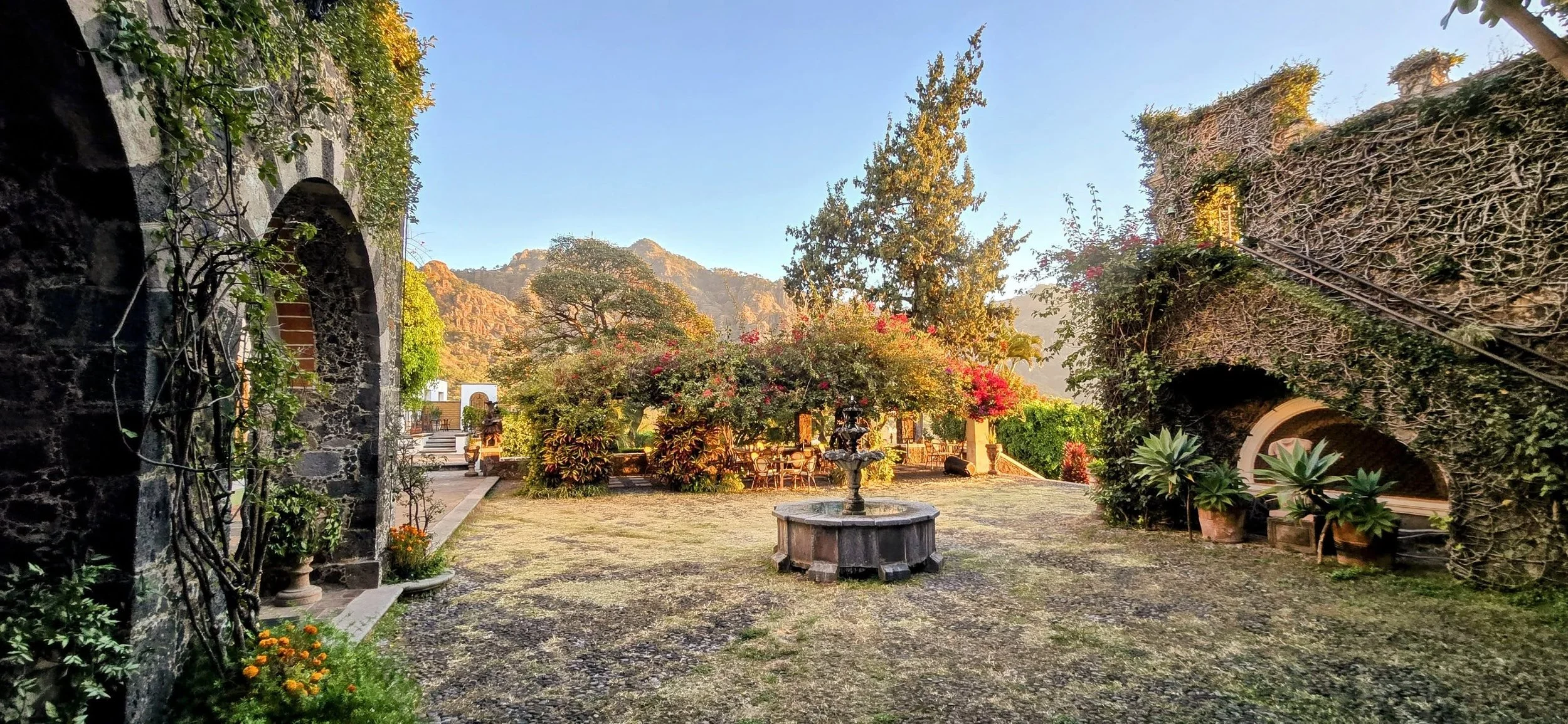
I stayed at the Posada del Tepozteco, an upscale hotel with an unbelievable view and large, luxurious rooms. That said, many private and trendy, health & wellness retreats are scattered throughout town and if I had known sooner, I might have stayed at one. The advantage of Posada is that it's a few minutes' walk to Avenida Revolución, whereas many of the retreats are much farther.
Tepoztlan is highly regarded for its diverse and vibrant wall murals and one of my favorite things to do was wander and photograph them. The town's streets are often described as a "canvas" depicting Mexican culture, history, and whimsical fantasy. Although I can't remember the exact street of this photo, it's just to the right off Avenida Revolucion as you start approaching the Pyramid hike entrance.
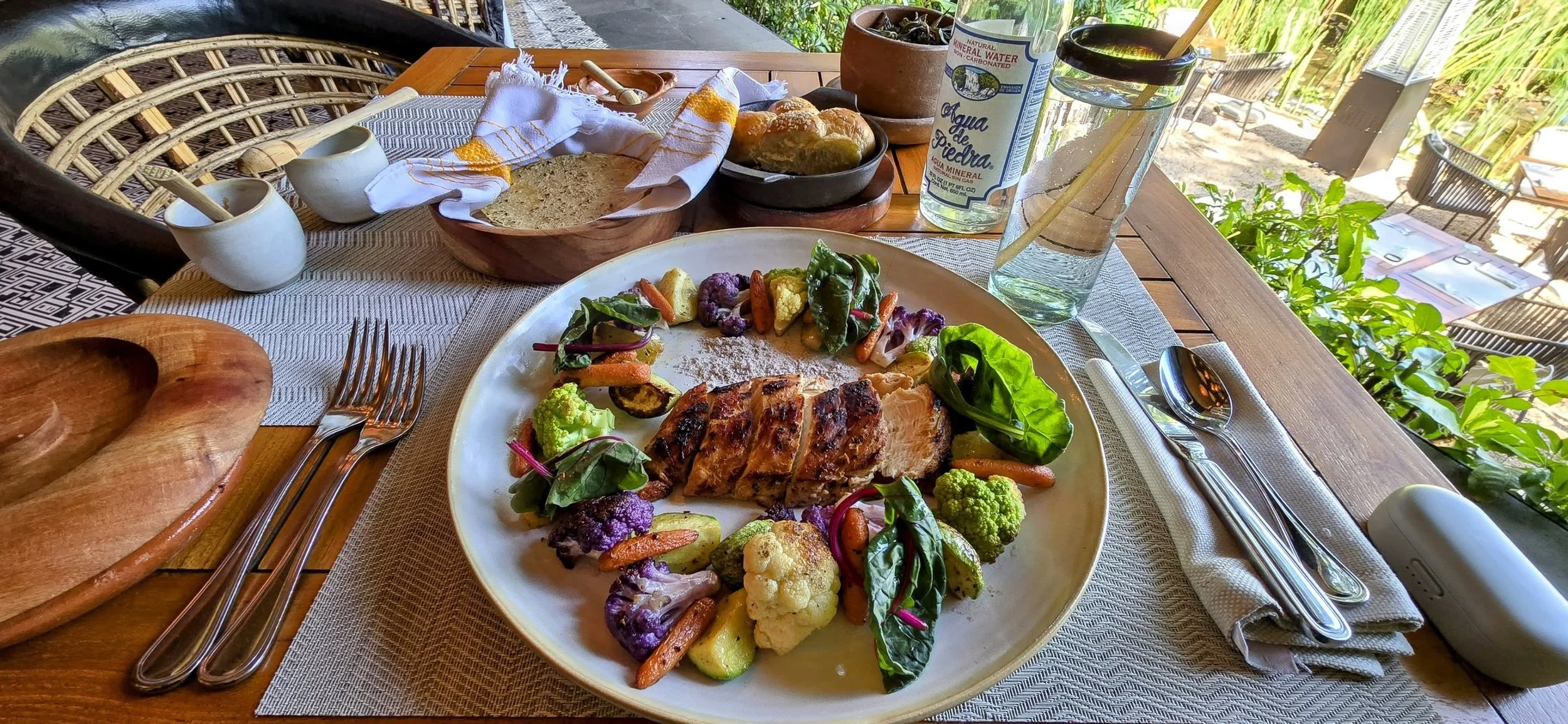
The local cuisine in Tepoztlan is healthy and amazing, but you need to get away from Avenida Revolucion to find the hot spots. I must have eaten this dish three days in a row at Mesa de Origen, the signature restaurant of the Amomoxtli boutique hotel.
Hiking to El Tepozteco Pyramid is one of the most popular activities and offers panoramic views of the valley. It's a steep, rocky trail to reach this 13th-century temple dedicated to the Aztec god of pulque. The hike takes only 1-2 hours depending on your fitness level, but it was more challenging than I expected. The hours might vary, but it's generally open M-Su 9am- 5pm and costs $90 pesos--I tried to go earlier, but a gated door prevented entry until security arrived. The trailhead starts at the end of Avenida Revolución, heading toward the majestic mountains. You'll pass through many vendor tents selling all kinds of things and friendly dogs lying on the wooden walkway. You might even see Coatis, diurnal mammals in the raccoon family; they are curious little critters, but not dangerous. Once at the top, climb onto the small pyramid to get this photo!
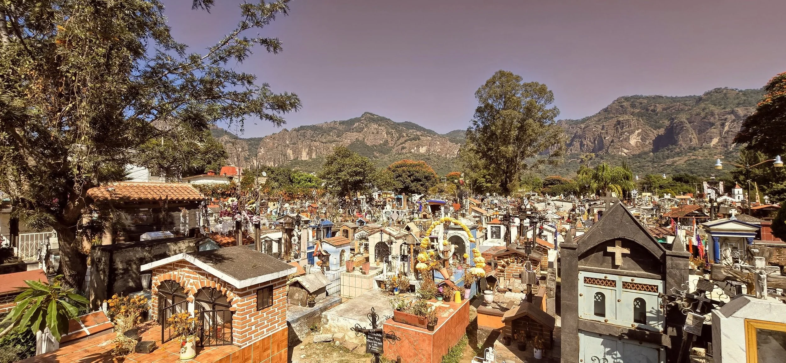
While wandering the Tepoztlán neighborhoods, I somehow stumbled upon the local cemetery, and it was spectacular. It's considered special primarily for its deep cultural atmosphere and how it transforms during the Day of the Dead. Furthermore, the cemetery offers amazing views, particularly during the golden hour when the sunset casts a magical glow over the decorated tombs against the backdrop of the town's famous cliffs. I took this photo from the entrance while standing on one of the wall's ledges. I'm not sure if exploring the cemetery's interior was allowed, but the groundskeepers didn't seem to mind.
A few other activities include exploring the Ex-Convento de la Natividad (16th century monastery), visiting the Weekend Market and Museo Carlos Pellicer.
Tlayacapan
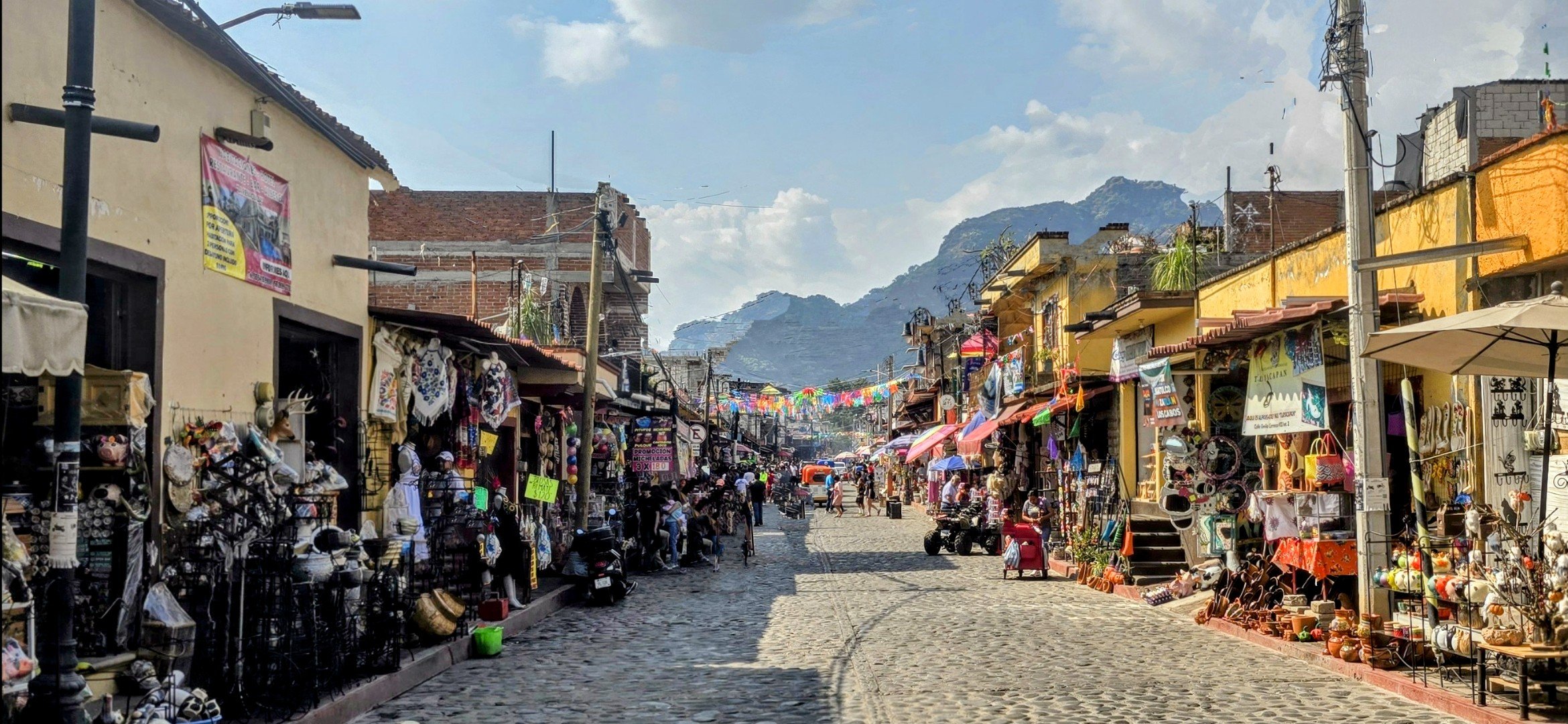
Tlayacapan is another picturesque Pueblo Magico in the state of Morelos, just a quick 30-minute drive or taxi from Tepoztlán, where you can spend half a day. It's renowned for its 16th-century Augustinian monastery, a thriving pottery tradition, and its status as the birthplace of the iconic Chinelo dance. It's got the same relaxed, bohemian vibe but is even more remote and less touristy. For me, I enjoyed wandering the streets, browsing the local vendors and trying their famous red and green pipian with tortillas. This photo, taken from the entrance of the main street in the historic zone, looks toward the mountains. Unfortunately, it's almost impossible to take a photo without including others.
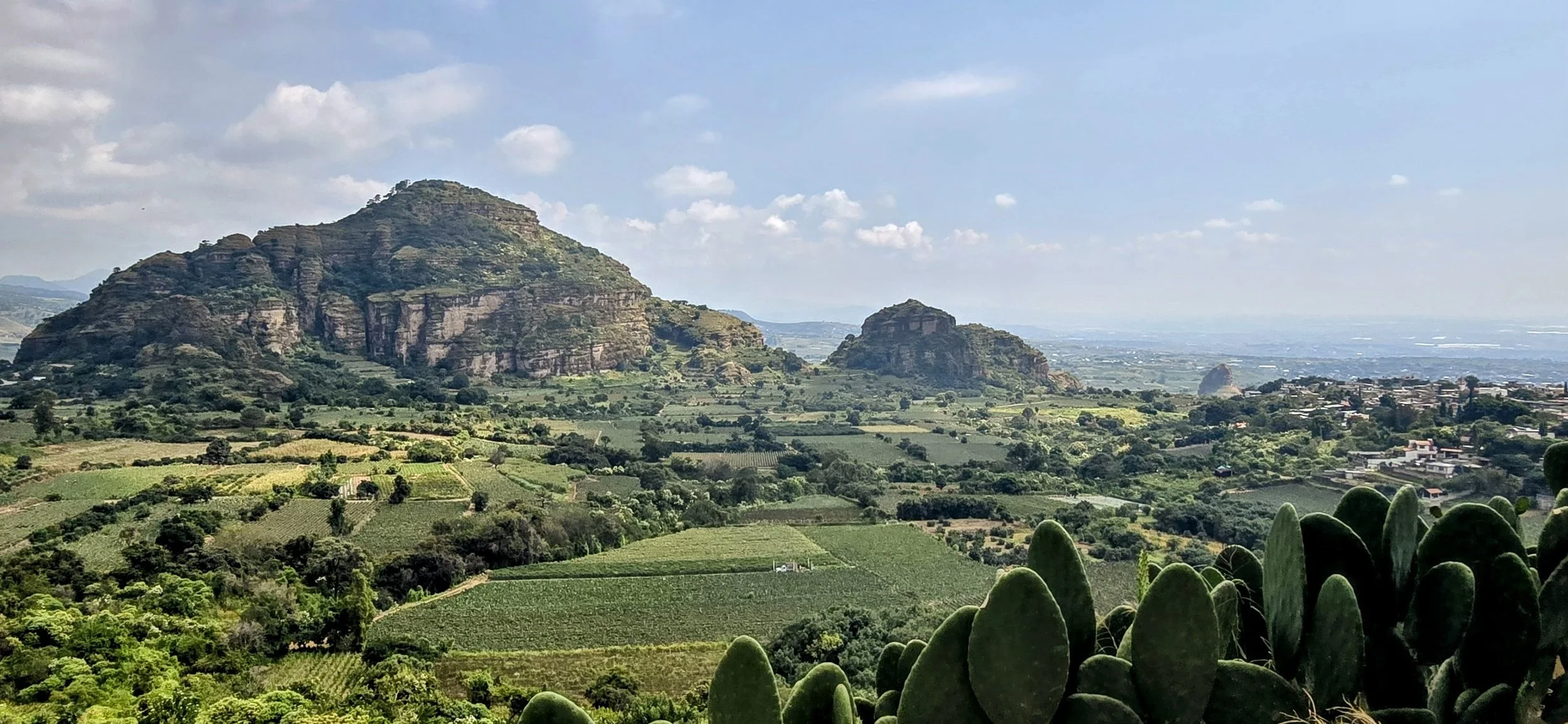
Mirador Amatlan de Quetzalcoatl is approximately a 30 minute drive from Tlayacapan, but you'll definitely need a car for this activity. This is a remote, mountainous area, offering hiking and a few off-roading trails. The hike to the mirador is 2.5 miles and takes approximately 2 hours to complete. However, I'd recommend trying to find a few of the off-roading trails for a quicker drive to the top--I can't remember the exact road, but since there aren't many, it should be easy to find. This photo, taken just before reaching the top, looks over the valley. You can actually climb the mountains in the photos, but I don't think it's worth the time.
Nevado de Toluca
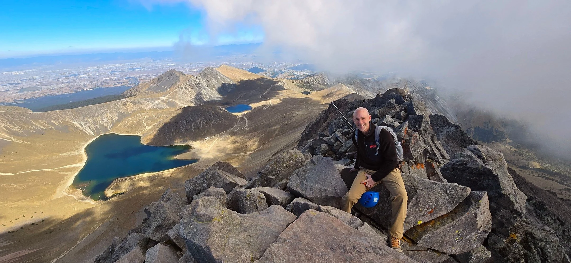
Hiking Nevado de Toluca (also known as Xinantecatl) was one of my favorite activities in all of Mexico and a "must-do" for adventure seekers. It offered a unique high-altitude experience inside an extinct volcanic crater containing two stunning alpine lakes: Laguna del Sol and Laguna de la Luna. I booked an all-day tour through GetYourGuide that picks you up and drops you off at your CDMX accommodation. You'll most likely join 3-4 other solo hikers and I believe the tour costs approximately $165 USD before adding a tip.
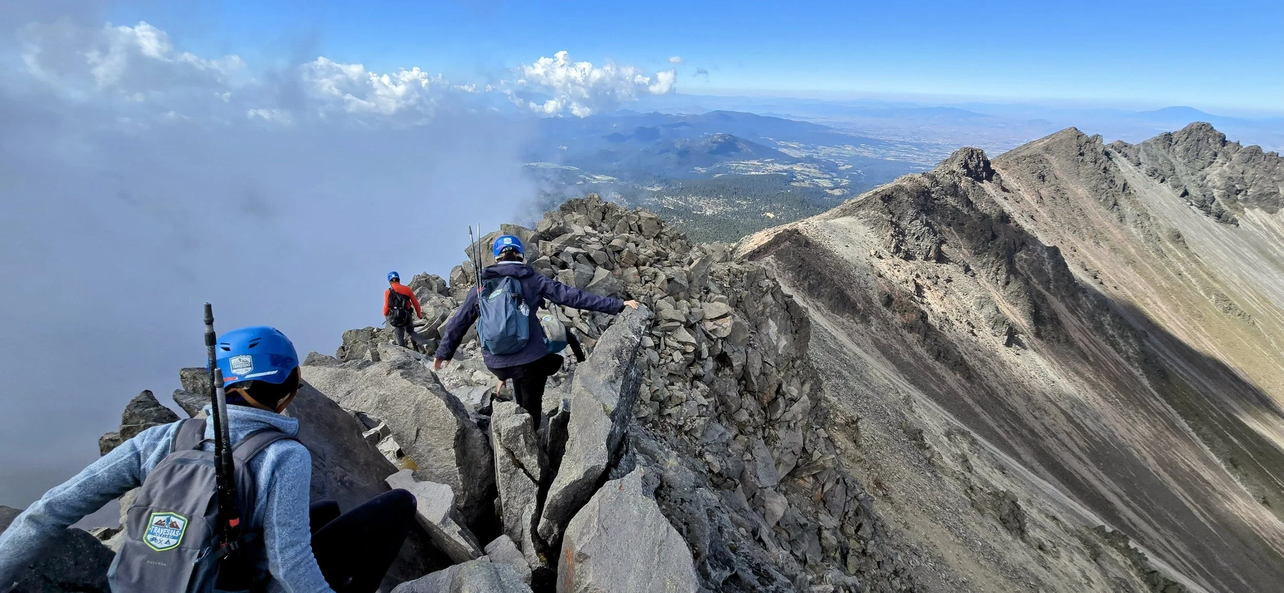
The drive from CDMX to the trailhead is a scenic two hour journey. The trail starts at approximately 13,123 feet, making the thin air the primary challenge. However, this trail isn't for the faint of heart and you must be in good shape; it requires navigating steep, rocky ridges and Class 2-3 scrambling at more than 15,000 feet. If you're not experienced, I wouldn't recommend attempting this climb without a guide. Your guide will stop frequently to allow the group to catch their breath and take pictures. Both of these photos were taken from the rocky ridge and I must admit, the strong wind gusts made me a little nervous.
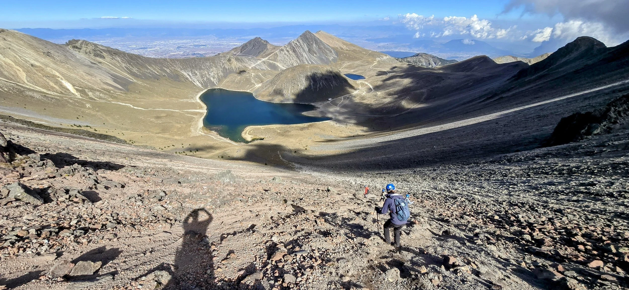
The descent was one of my favorite parts because it felt like you could "pretend-ski" down the gravelly mountainside. However, zig-zag your way; being too reckless can easily become quite dangerous. It's almost guaranteed that everyone in the group, including your guide, will take at least one small fall! Your guide will most likely treat the group to a small, rustic roadside restaurant (fondas) before arriving back at your hotel around 8-9pm. The fondas serve some of the most authentic and delicious tacos and local Mexican cuisine.
Within a Few Hours North of CDMX
The following locations are all within a 3-to-4-hour drive of Mexico City.
Queretaro
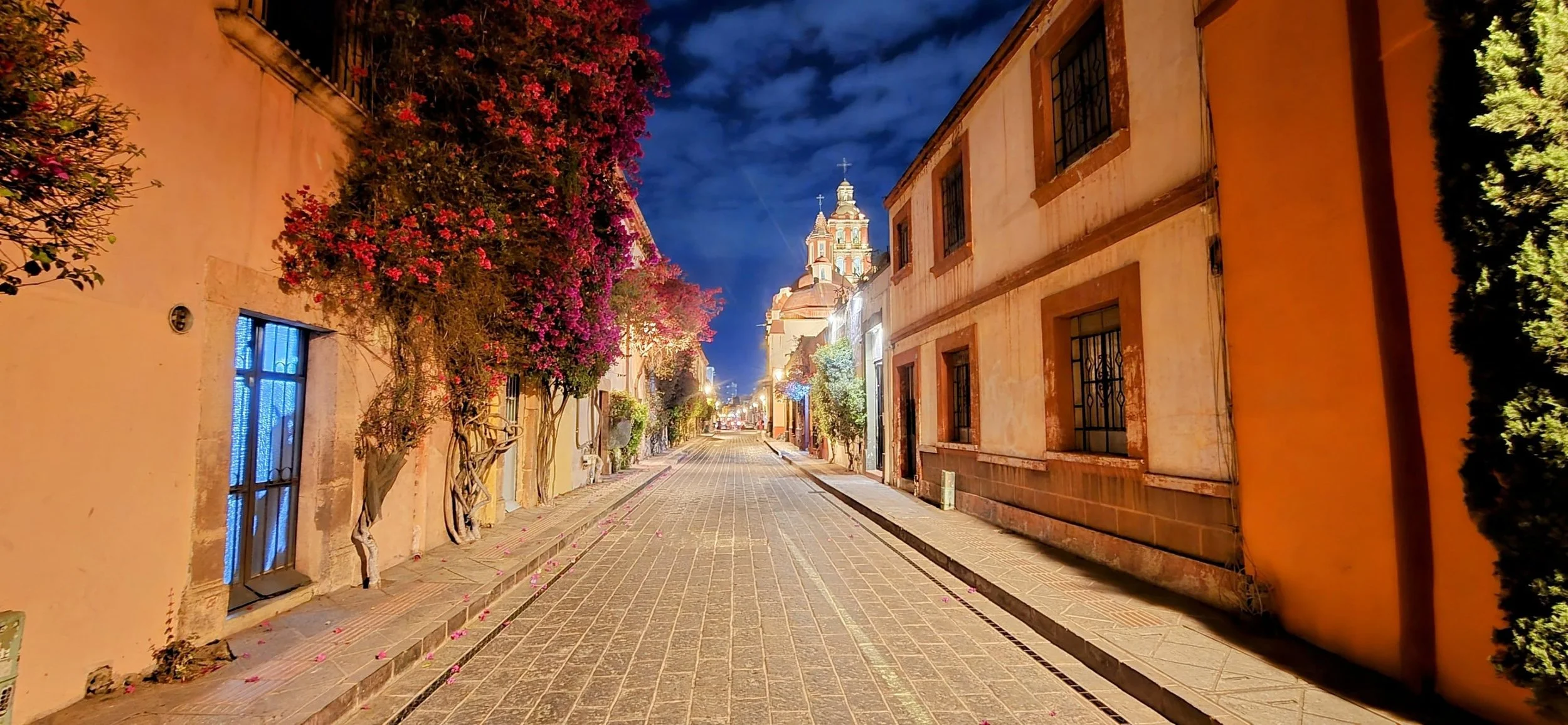
Queretaro is a vibrant state and city located in the central highlands of Mexico. It is widely recognized for its high quality of life, economic growth, and beautifully preserved colonial history. The city is approximately a 3 hour drive northwest of Mexico City and tolls cost $12 one-way. Queretaro was one of my favorite cities because it was safe, clean, had perfect weather, and was upscale, offering many art galleries and photogenic streets, especially in the evening. This photo was taken from one of the colonial streets while wandering the artsy historical center. One full day is enough to explore this city of just over a million people.
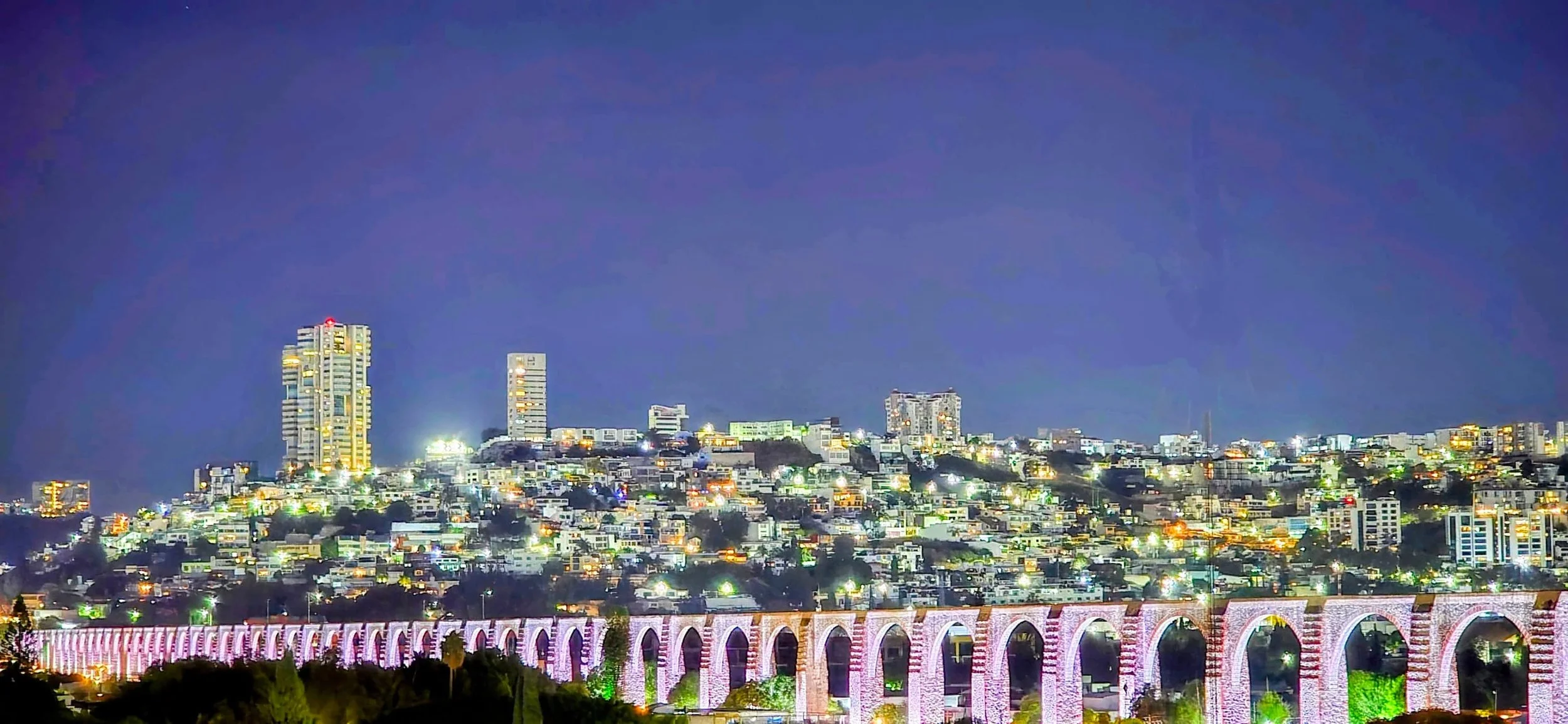
The Aqueduct is one of Querétaro's most photographed structures. I recommend visiting Mirador de los Arcos at sunset for the best panoramic view of the 74 massive stone arches that define the city's skyline. You will also find local food trucks and music at the mirador, however, it's never too crowded.
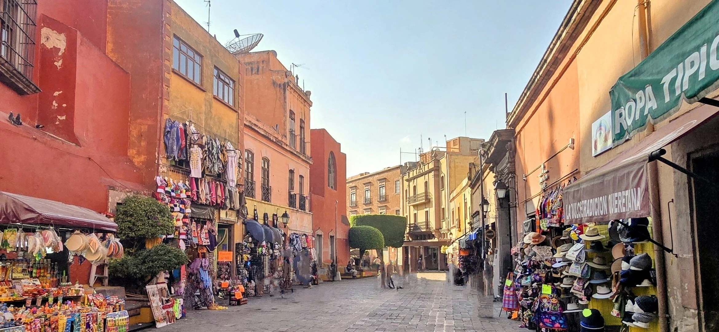
You can wander the artsy historic center's Plaza de Armas and Jardin Zenea to see the heartbeat of the city. I believe this photo was taken from 16 de Septiembre calle, but I could be slightly off.
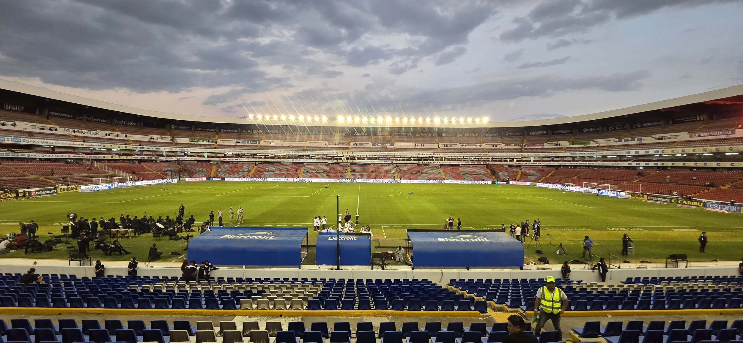
The local professional soccer team is Queretaro Futbol Club, widely known by their nickname Gallos Blancos (Wild Roosters) and they compete in Liga MX, the top division in Mexican soccer. The team is always in the bottom half of the standings and the stadium is falling apart. However, I wanted to see a game because I heard about their notoriously, violent fan base and wanted to experience it myself. As someone who grew up attending many Philadelphia Eagles games, this Mexican soccer game seemed normal to me. This photo was taken from the home side's half-field line. It's very easy to move up seats depending on the crowd size.
Pena de Bernal
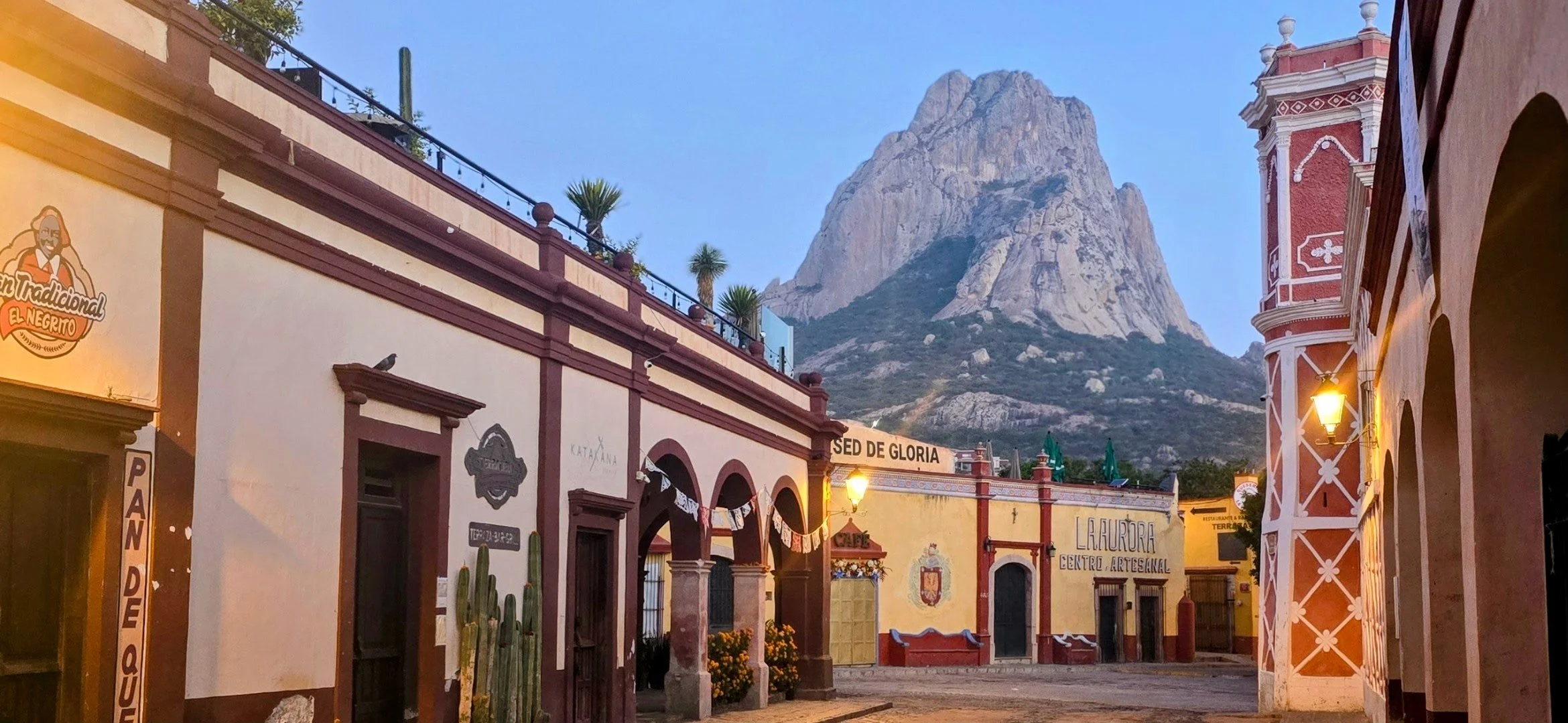
Pena de Bernal is considered a "Magic Town" located approximately 45 minutes northeast of Querétaro. It can easily be visited in one day, but I recommend spending the night. For those adrenaline seekers, the monolith is one of the world's tallest free-standing rocks, popular for hiking and climbing. This photo, taken in the early morning hours was from the Main Plaza, is Instagram iconic: the Iglesia de San Sabastian (church) in the main plaza acts as a foreground element with the Pena towering behind it.
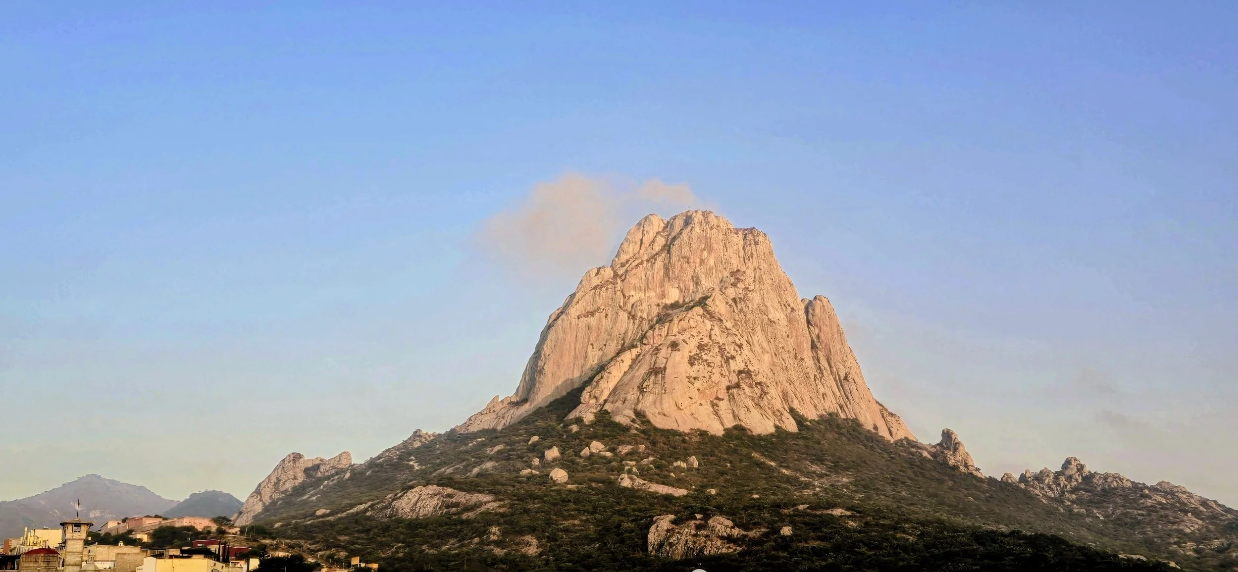
Most adventure companies offer climbing tours for beginners to advanced levels, but you should be in good physical shape regardless of your skill level. I booked an intermediate level climb through a private guide via 57 Hours which costs around $400 not including a tip. Unfortunately, I left my phone in the car and couldn't take any photos, but it was an unbelievable experience that I highly recommend if you're comfortable with scary heights. Another option is to hike up to a high vantage point, though the ascent can be steep and often hot. This photo was taken from the rooftop restaurant at Hotel Real de la Pena.
Other things to do in Bernal include: 1) Home of the Gordita Negrito, so you definitely need to try a spot in Zona Central (look up El Mezquite) 2) Visit a rooftop bar for a view of the monolith 3) Try Pan de Queso 4) Light show of Bernal at 8pm and 9pm. Most tourists leave town after dinner so you'll likely have the entire town to yourself in the evening. This photo was also taken in the main plaza square in the late evening.
The Sierra Gorda Mountain Range
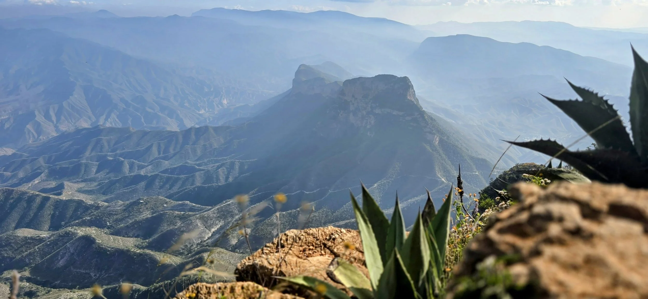
Pena de Bernal is considered the southern gateway to the Sierra Gorda mountain Range and is approximately 1.5 hours from the famous Mirador Cuatro Palos. The mountain range is famous as a UNESCO Biosphere Reserve featuring dramatic ecosystems and serving as a hotspot for jaguars and rare bird species. However, this area is much more popular with locals than with foreigners. The scenic bypass via Puerta del Cielo (Heaven's Door) to Cuatro Palos is fantastic. The small town next to Mirador Cuatro Palos is the community of Cuatro Palos, a small, rural settlement that manages access to the viewpoint. It is located about 3.5 miles off Highway 120 via a dirt road detour at the community of La Canada. The dirt road is very narrow and you might even wonder if you're going correctly, but you are! Once you reach the town, locals will charge a small entrance fee to visit the mirador, this fee supports the village's infrastructure. This is a third-world village and it's fascinating to watch the local kids playing soccer while the "ancianas" (older women) make handmade tortillas nearby. You only need a half a day at most for this entire excursion.
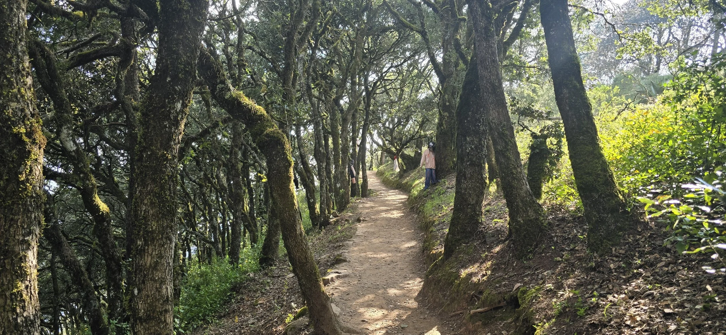
Arriving before 6am is best for sunrise and to see the "sea of clouds." It's a relatively short and easy hike (15-20 minutes) to the viewpoint, but it requires a mandatory guide-- I believe the cost is around $5 USD. While it is a major landmark in the area, the nature-focused trip makes it a scenic experience rather than a loud tourist spot. We got lucky visiting in November when the trails are decorated with "ahorcados" during Dia de Muertos (Day of the Dead), and other soul-themed items representing the "animas." The larger photo above was taken from the mirador and you might need to walk over the ropes to get the best picture--the guides don't typically care. The second photo was taken from the trail that runs along the mountain's edge leading to the mirador. The returning trail isn't nearly as scenic, although it's still littered with the creepy, hanging dolls.
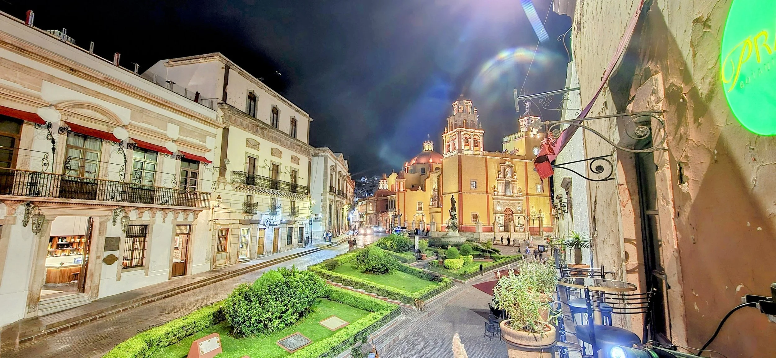
Guanajuato

From the Sierra Gorda, you can head approximately 4 hours west to Guanajuato, the last location north of CDMX. Guanajuato is a vibrant state and city, celebrated as one of Mexico's most colorful and historically significant destinations. It is a UNESCO World Heritage site known for its unique underground tunnel network, colonial architecture, and deep roots in the Mexican independence movement. Guanajuato is still under-the-radar for international tourism so you'll likely be one of a few foreigners. I stayed at Casa del Rector Hotel Boutique in the heart of the city and it was an extremely nice accommodation with a super cool rooftop bar and pool. The city is also considered a quintessential college town, centered around the historic Universidad de Guanajuato (founded 1732) which has buildings spread throughout the city. Needless to say, you might feel a little out of place here, but it's worth a visit for a day! The photo location is explained below.
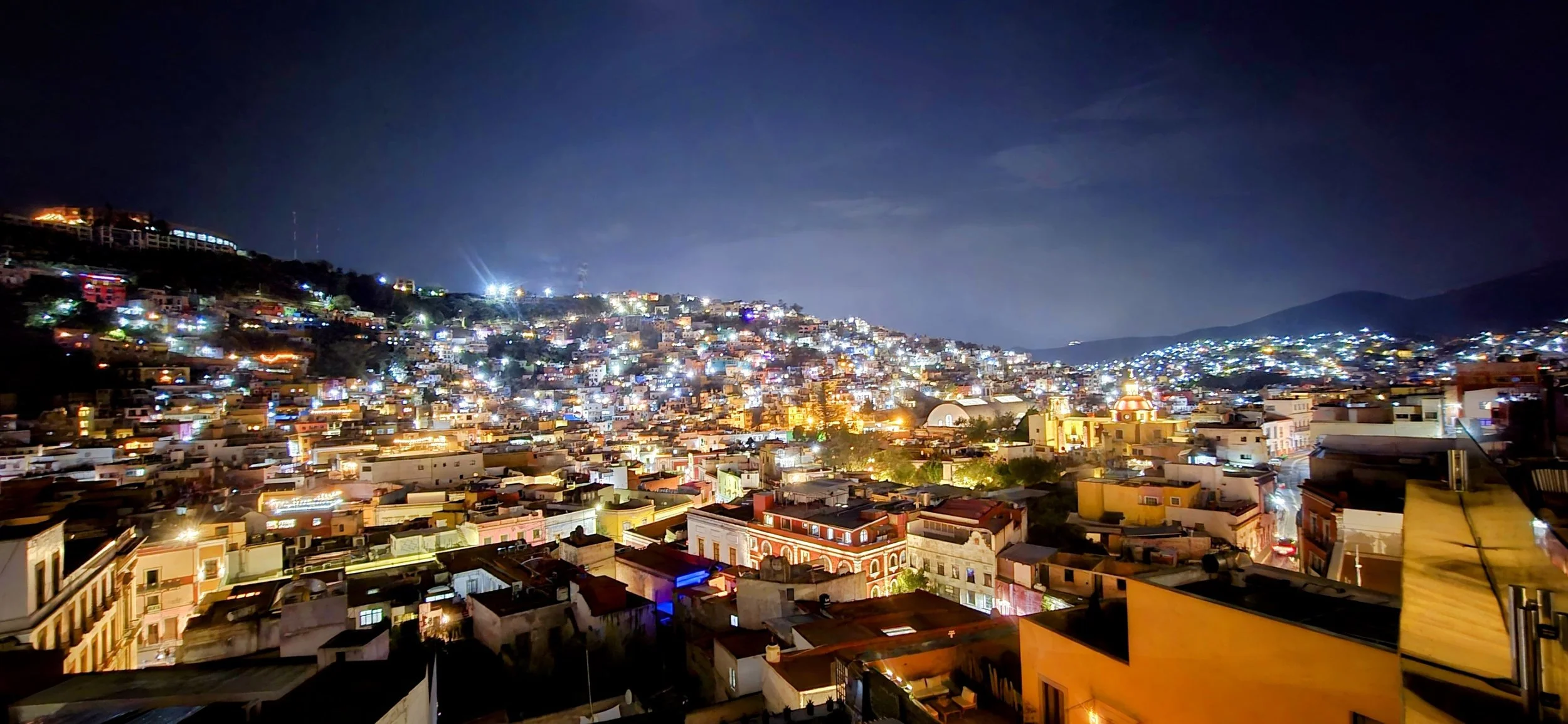
This photo was taken from the rooftop of my hotel, Casa del Rector. It's a great place to start your evening before heading to dinner or out for some drinks.
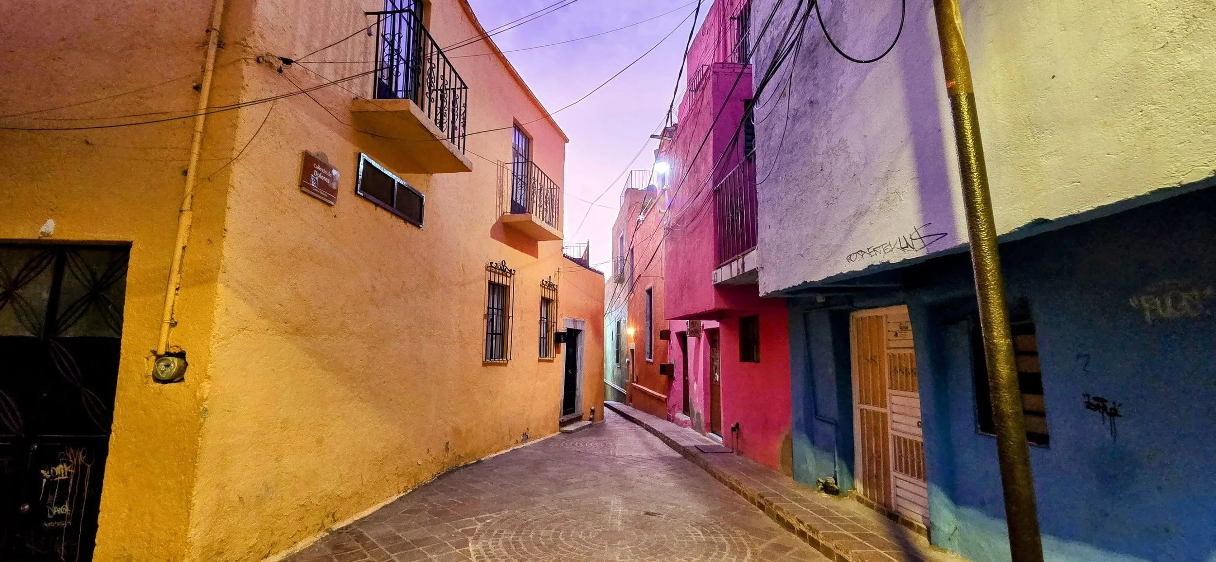
One of the most enjoyable activities in Guanajuato is wandering through the alleys to photograph the colorful walls and unique murals. Callejon del Beso (Alley of the Kiss) is probably the most famous alleyway where local legends say lovers can reach across the balconies to kiss. However, this photo was taken on the walk to the El Pipila Monument. As a rule of thumb, don't forget to look behind you or you might miss some of the best photos!
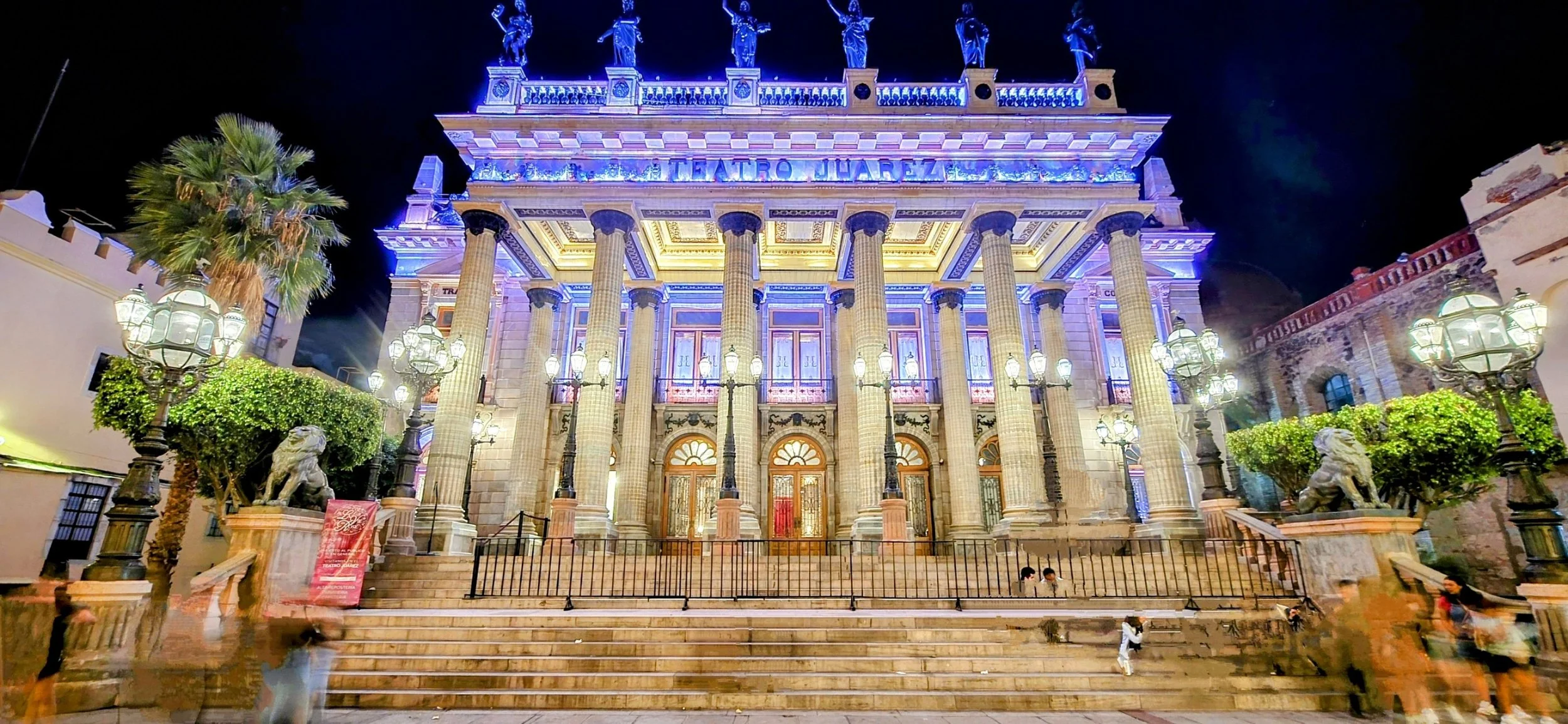
Teatro Juarez is one of Mexico's most beautiful theaters, reflecting the wealth of the city's 19th-century mining boom. You'll likely see many students hanging out on the steps in the evenings, as it sits a few steps from the Jardin de la Union.
This photo was taken from a square looking toward the Basilica de Nuestra Senora de Guanajuato (Our Lady of Guanajuato). This iconic 17th-century landmark is the centerpiece of the city's historic district and is easily visible from El Pipila Monument.
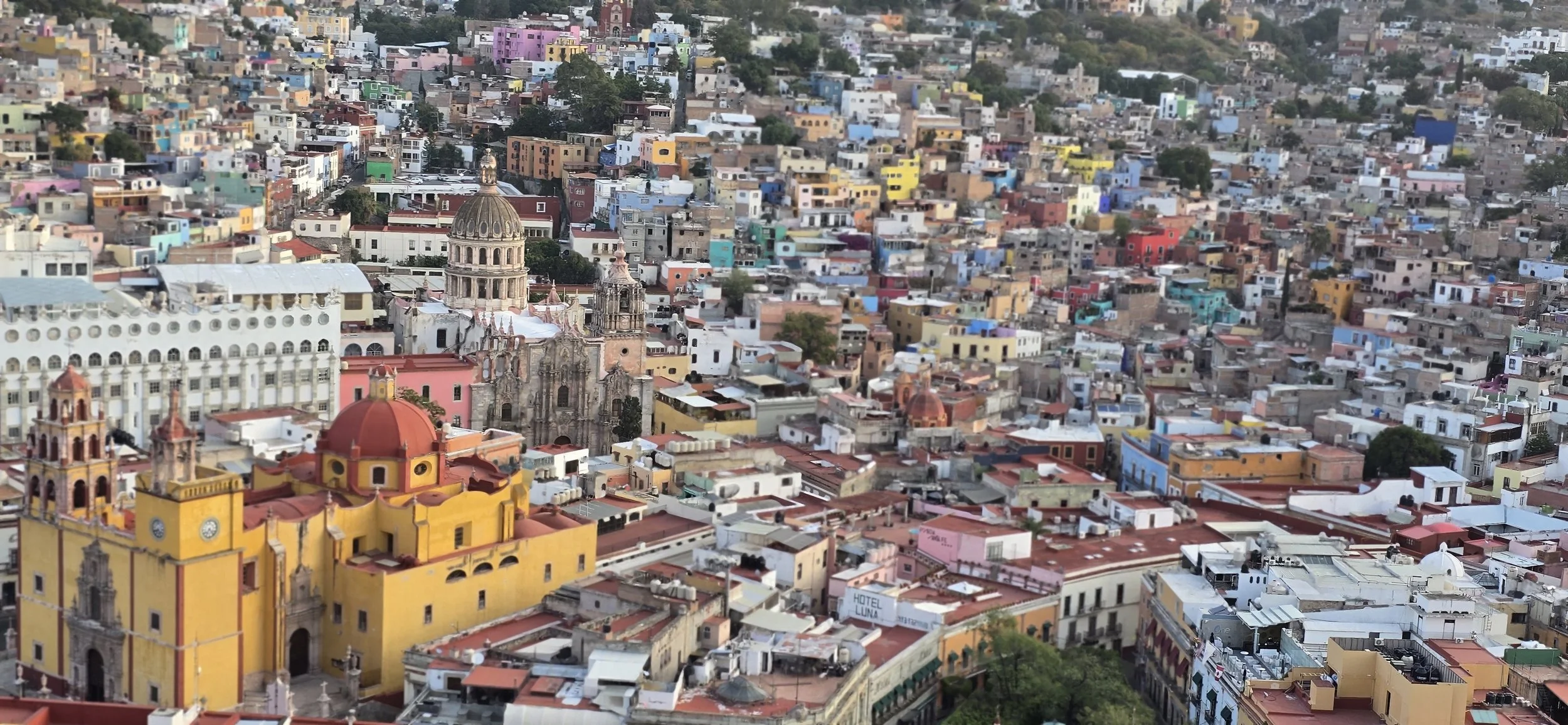
El Pipila Viewpoint is Guanajuato's most popular site, accessible via funicular (a cable-driven railway system) or by hiking. El Pipila (Juan Jose de los Reyes) is the legendary hero of Guanajuato and a pivotal figure in the Mexican War of Independence. His statue sits directly next to the viewpoint. I strongly recommend hiking to the viewpoint because it only takes 20- 30 minutes from the historic center and passing through all of the colorful alleyways is super cool. This photo and the photo above were taken from the viewpoint, however, the lookout area is large, allowing you to choose from many angles.
Within a Few Hours East of CDMX
The following locations are all within a 2-to-3-hour drive of Mexico City.
Val’ Quirico
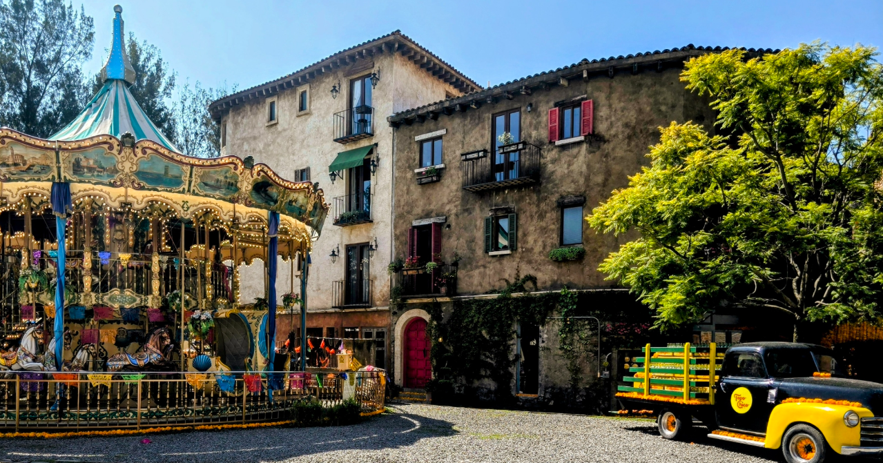
The first destination to the east is Val' Quirico, a themed residential and tourist development in the state of Tlaxcala. It's approximately two hours from Mexico City and designed to resemble a medieval Tuscan village. It was built in the 21st century on the site of a former hacienda and features cobblestone streets, stone facades, and rustic European architecture. In my opinion, Val' Quirico felt more like a tourist trap and you wouldn't miss much if you decided to spend more time elsewhere. If anything, you only need a few hours to explore the boutique shopping, gastronomy and snap a few "Instagrammable" photos. This photo was taken near the village entrance; arrive super early to avoid crowds.
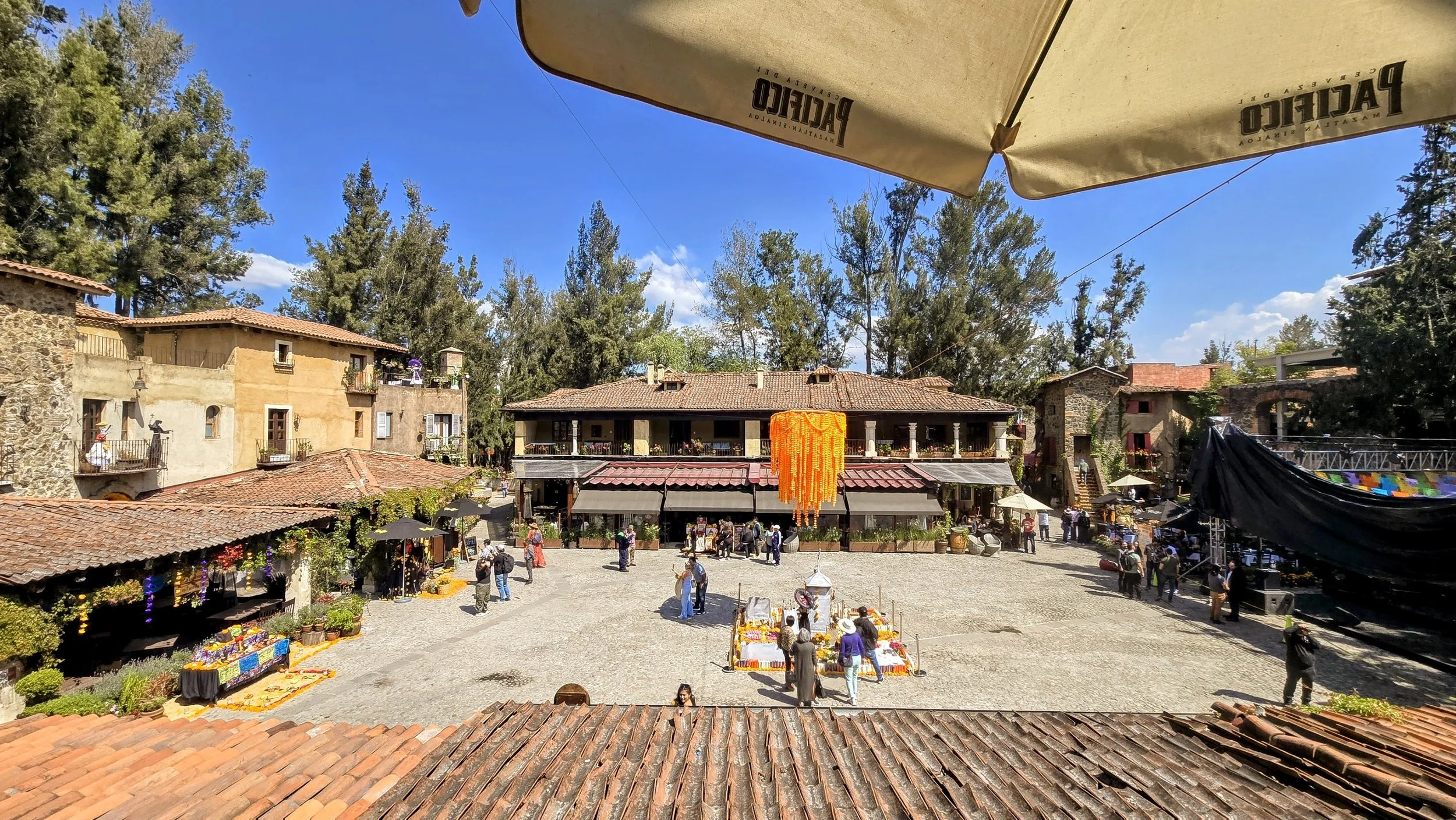
There is generally no admission fee to enter the village, but parking requires a charge. I believe the operating hours are from 8am- 9pm and the best time to visit is on the weekdays to avoid the large crowds. I noticed that a few of the more popular dining spots included La Luna Sul Mare (Italian) and Meson de los Reyes (Spanish). In fact, Val 'Quirico reminded me of many small towns in Spain. This photo was taken from the main square from the second floor of a popular restaurant.
Cholula
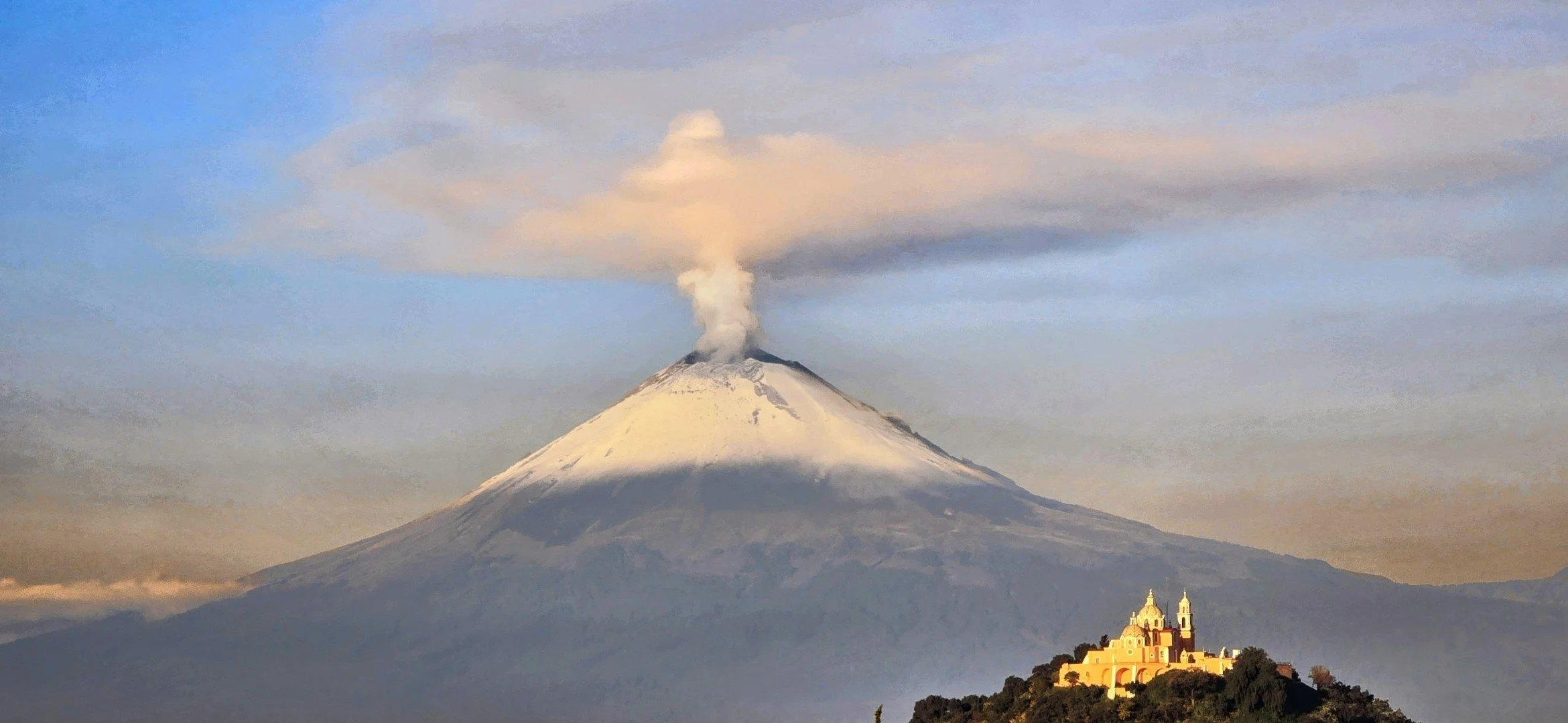
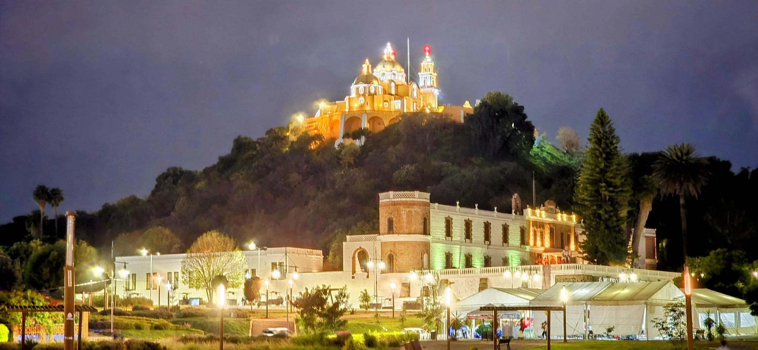
From Val 'Quirico, you'll head 20 minutes south to your second destination, Cholula. The drive from CDMX and both towns can easily be combined into one day. Cholula is another vibrant "Pueblo Magico" in the state of Puebla, famously known for hosting the world's largest pyramid by volume. It's also recognized as Mexico's oldest continually inhabited city, with a history spanning over 2,500 years. The Great Pyramid is often mistaken for a natural hill, but this "made-by-hand mountain" has a volume nearly double that of Giza's Great Pyramid. As seen in my photos, a bright yellow colonial church is perched directly atop the hill, offering panoramic views of the city. However, I couldn't reach the top because it was closed by the time we arrived in the evening. Above is the iconic, Instagram photo of the church and Popocatepetl Volcano but I'm not aware of an actual viewpoint. We must have driven for an hour in the early morning before pulling over on a highway onramp to capture this perfect photo. It's nearly impossible to find this location on the map, but wake up extra early to secure a great spot before sunrise.
In case you're wondering, Cholula Hot Sauce was named after the city, but the sauce was actually founded in Jalisco. We didn't stay in Cholula for too long because we spent more time in Puebla and Atlixco. However, other activities include: 1) Archaeological Zone Tunnels where you can walk through roughly 800 meters of illuminated tunnels deep inside the pyramid; 2) Convento de San Gabriel Arcangel, located in the Zócalo, which is one of the oldest Franciscan friaries in Mexico; and 3) Zocalo (Plaza de la Concordia), a long, tree-lined main square bordered by the Portales, where you can find numerous cafes and restaurants.
This photo was taken from the park with the large San Andres letters--I believe one of the main entrances to the pyramid.
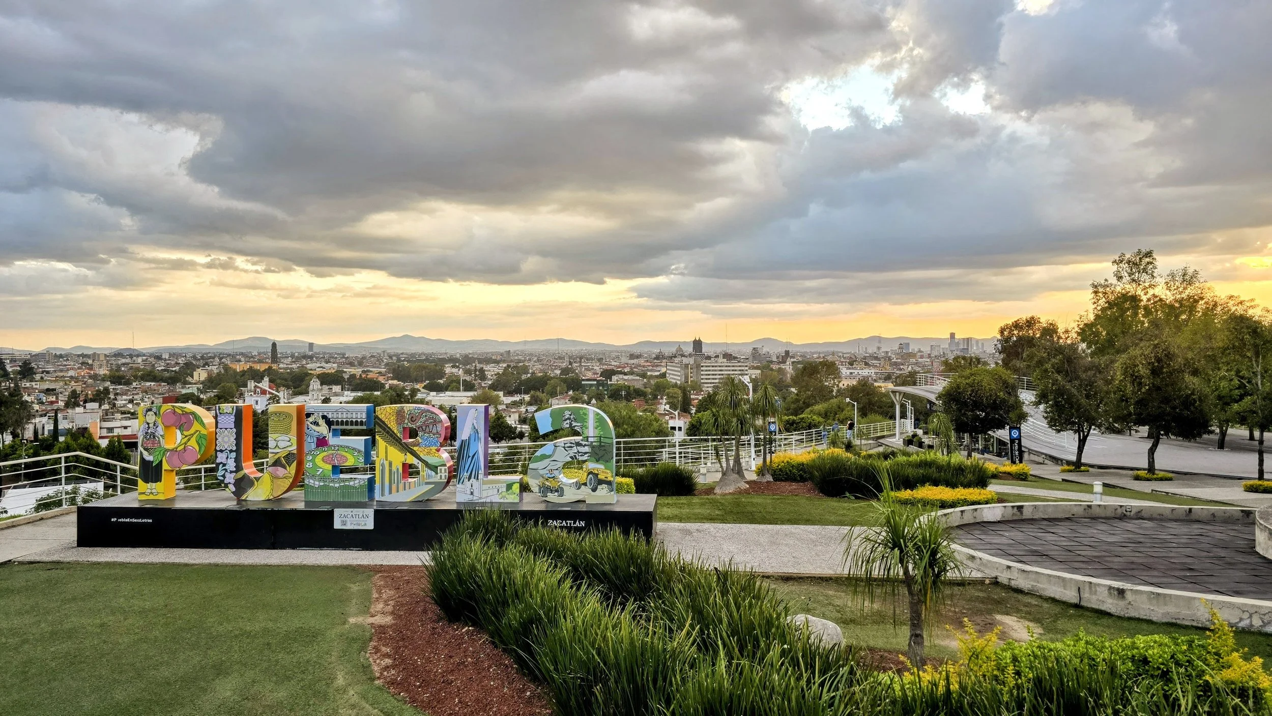
Puebla
From Cholula, it's a quick 25 minute drive east to Puebla, Mexico's fourth-largest city where you can easily spend one full day. The city sits on a high plain over 7,000 feet above sea level, framed by the dramatic volcanic peaks of Popocatepetl and Iztaccihuatl. In my opinion, the top things to do here include: 1) visiting the Puebla Cathedral, a magnificent 16th-century structure dominating the city's central square, the Zócalo; 2) the Capilla del Rosario, located inside the Church of Santo Domingo, this chapel is often called the "Eighth Wonder of the World" for its stunning, opulent gold-leaf Baroque interior; 3) Callejon de los Sapos, a vibrant street famous for its colorful colonial buildings, antique shops, and flea markets; and 4) Gastronomy--Puebla is widely considered Mexico's culinary capital, having birthed several of the country's most iconic dishes. This photo was taken from Mirador de los Fuertes, located within the Historic Zone of the Forts. It is approximately a 10-minute drive or a 30-minute walk from the city center. A few other tour buses will likely be here around sunset.
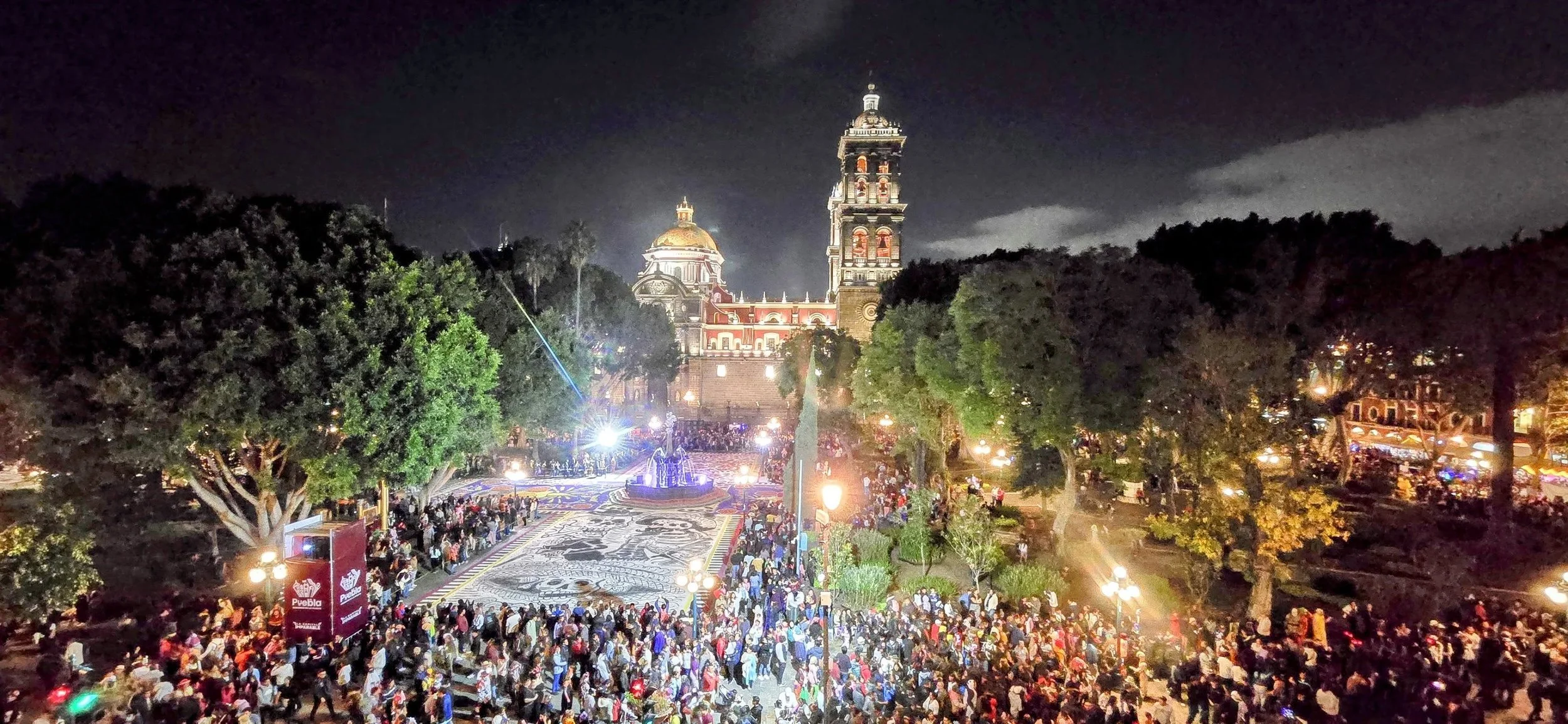
I was lucky enough to be in Puebla for Day of the Dead (Dia de Muertos) which is celebrated from late October to early November. It features vibrant and elaborate streets and cultural parades in the historic center. Thousands of people flock to the Zócalo, and it almost feels like New Year's Eve. This photo was taken from one of the second story bars overlooking the main square. Arrive early because the rooftop restaurants and bars fill to capacity.
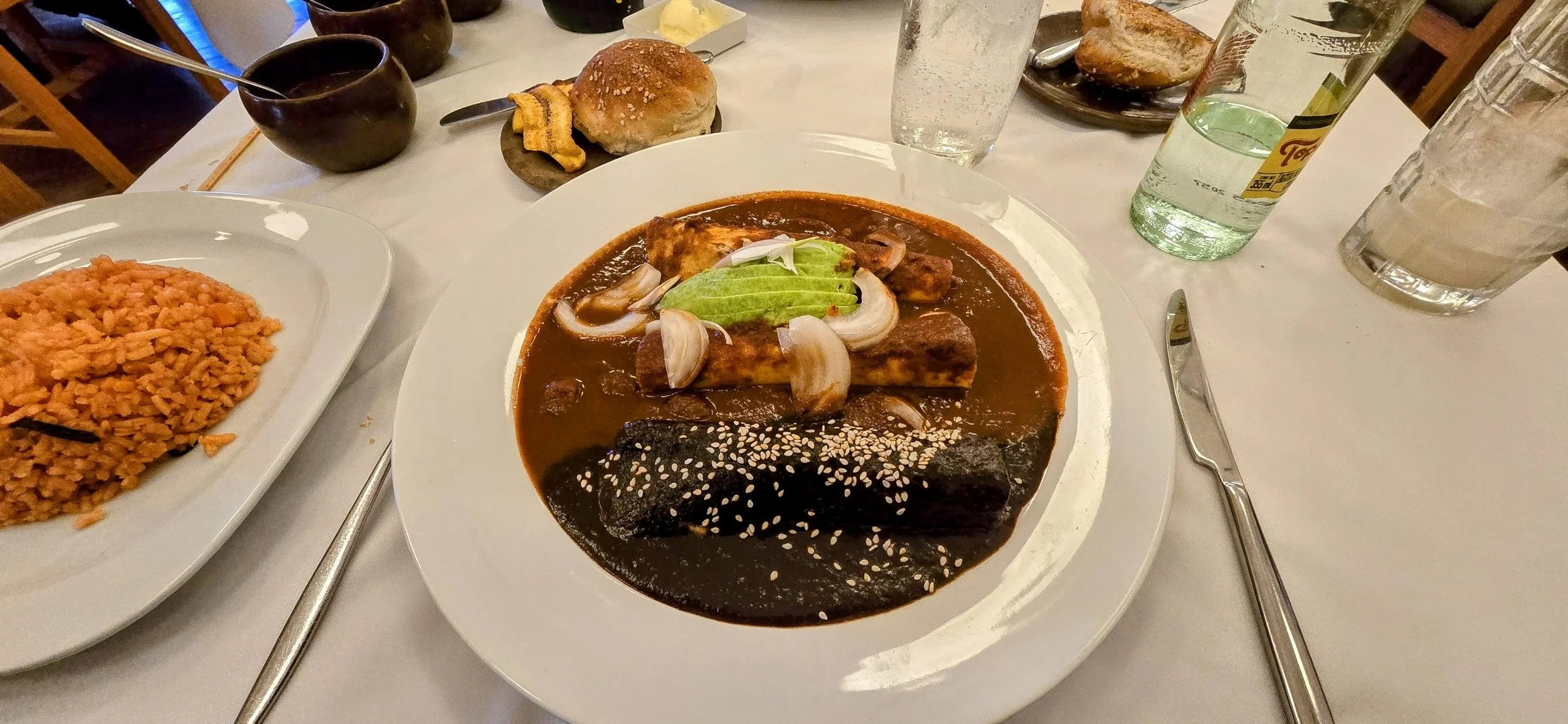
My favorite part about Puebla was the food, especially because they invented mole sauce! These enchiladas at the El Mural de Los Poblanos restaurant are covered in three different types of mole, but the chocolate mole was the winner. This restaurant is iconic and always packed so you'll want to make a reservation.
Atlixco
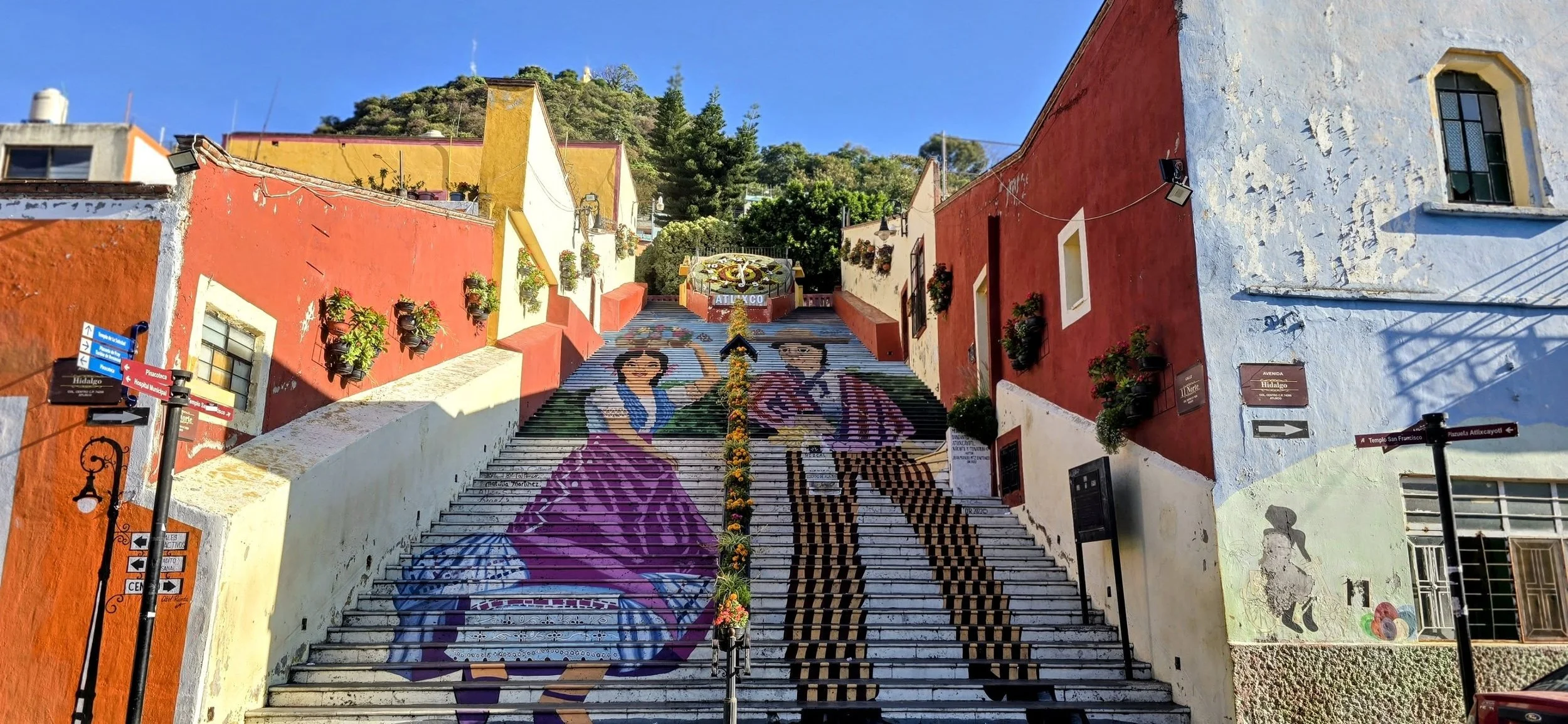
The small city of Atlixco, also known as the "City of Flowers," is located approximately 40 minutes southwest of Puebla. Again, it's another Pueblo Magico in the state of Puebla, celebrated for its year-round spring-like climate, colonial architecture, and massive flower production. The easily walkable city can be covered in a half a day and is not to be missed, as it's one of the prettiest areas east of CDMX. For me, the coolest attractions included La Escalera Ancha, Cerro de San Miguel, the Zócalo, and Avenida Hidalgo (Street of Flowers). This photo was taken from the bottom of La Escalera Ancha and capturing one without tourists is a waiting game.
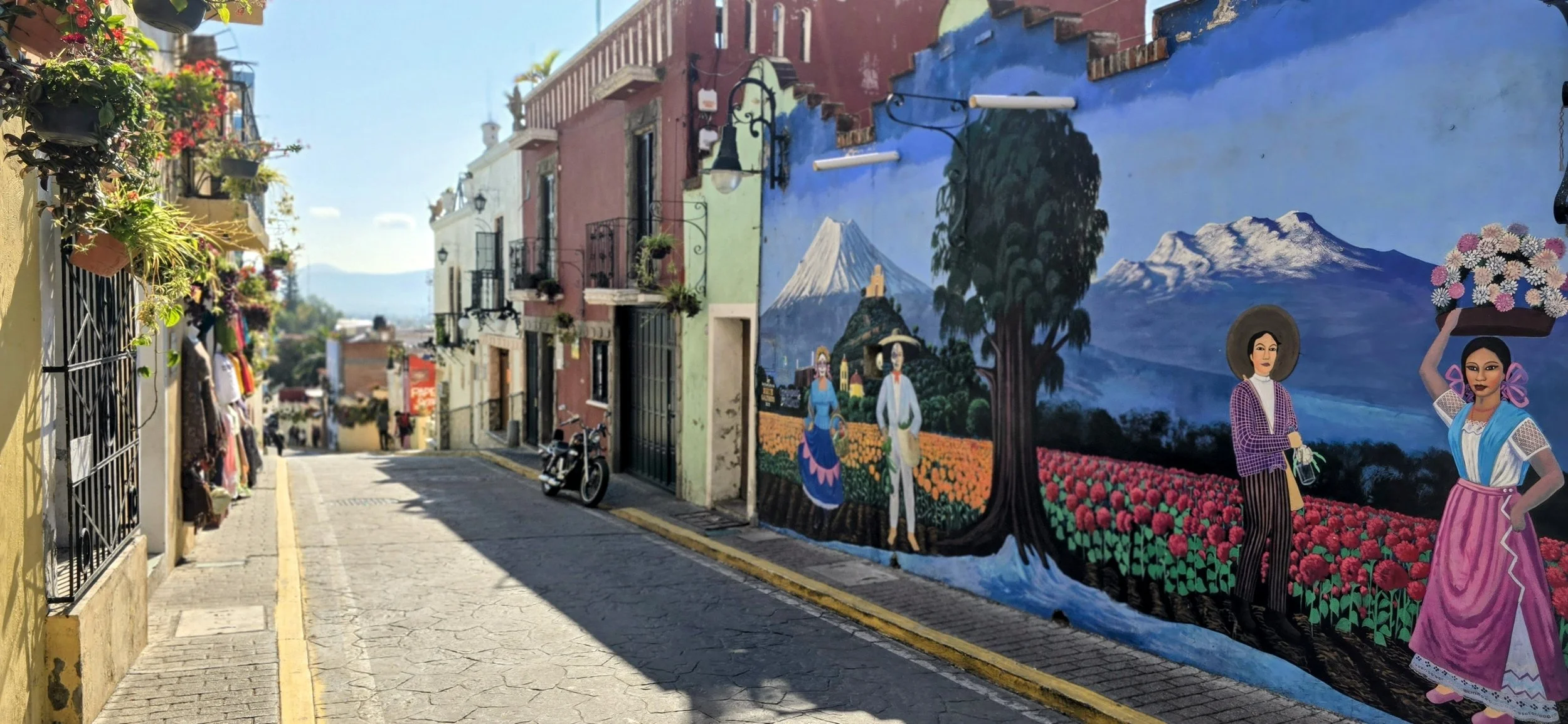
This was one of many colorful and colonial streets near the Escalera. Don't forget to look behind you or you might miss some of the best photo opportunities! Wandering the streets of Atlixco was the most fun part of the city.
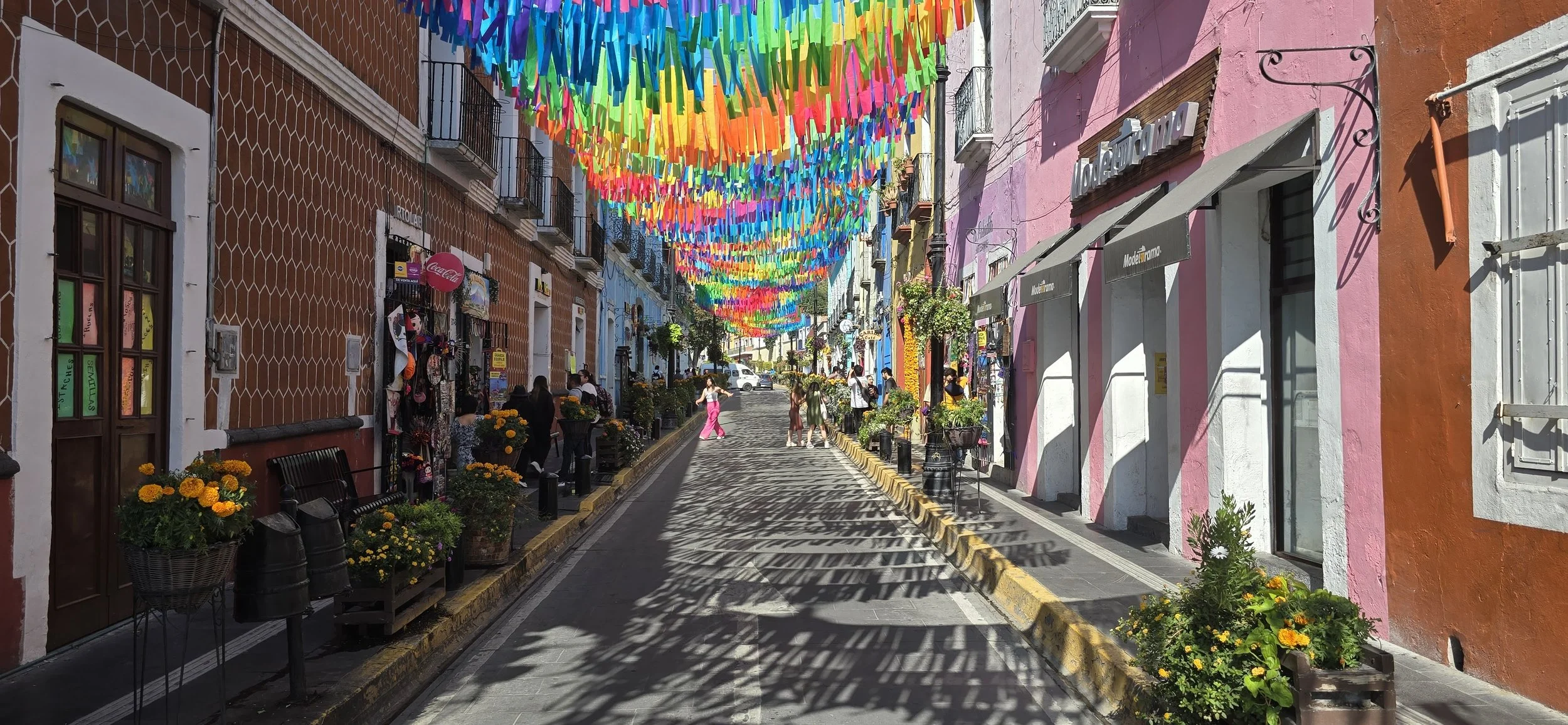
Although this isn't Avenida Hidalgo, it was one of the prettiest small streets near the Zocalo (main square). Capturing clean photos is difficult due to the tourists and passing cars; it requires patience like the Escalera.
This photo of the valley below was taken during the Cerro de San Miguel hike which lasts no more than an hour. On a clear day, it offers panoramic views of the city and the nearby volcano. At the top, you'll find the Capilla de San Miguel Arcangel. Although touristy, it isn't too crowded given the moderate hike up.
Pachuca
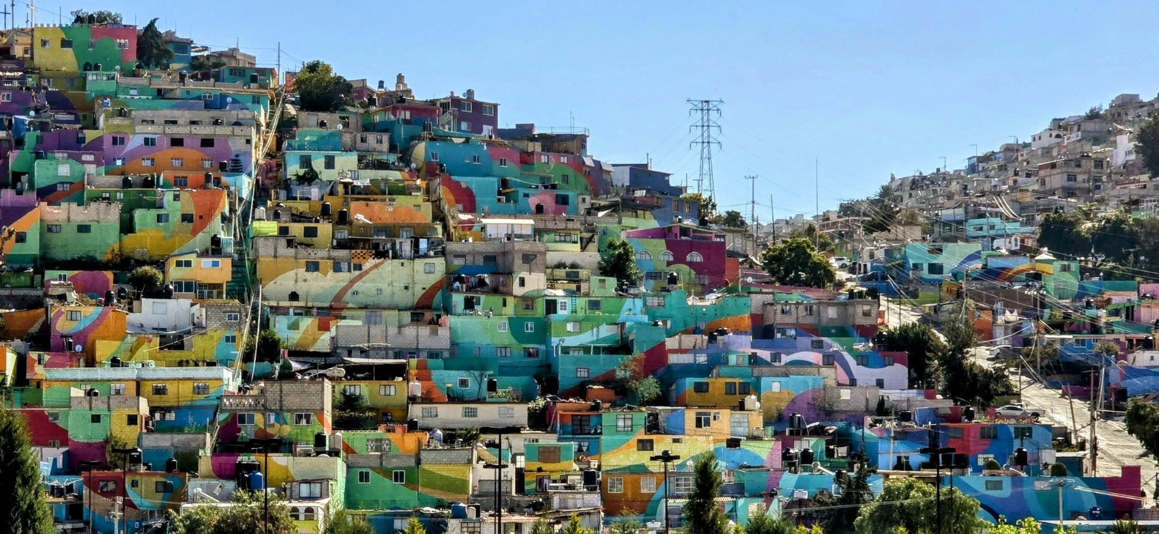
From Atlixco, you have two options: 1) head back to home base in CDMX to spend a few days relaxing and sightseeing, and then go to Pachuca or 2) drive two hours north from Atlixco to Pachuca (recommended). You should only need two full days to visit Pachuca and Mineral del Chico, perhaps three days if you visit a few other nearby towns. I suggest staying in Plaza Independencia (the main square) because it's closest to all the action and the safest area. We stayed at one of the more luxurious hotels on the footsteps of the plaza, Hotel Capitalino. Pachuca is the capital of the state of Hidalgo and is known as "La Bella Airosa" (The Beautiful Windy City) because of the strong winds that sweep through its canyons. Also known as the "birthplace of football in Mexico," the city hosts the International Football Hall of Fame and the interactive Mundo Futbol museum.
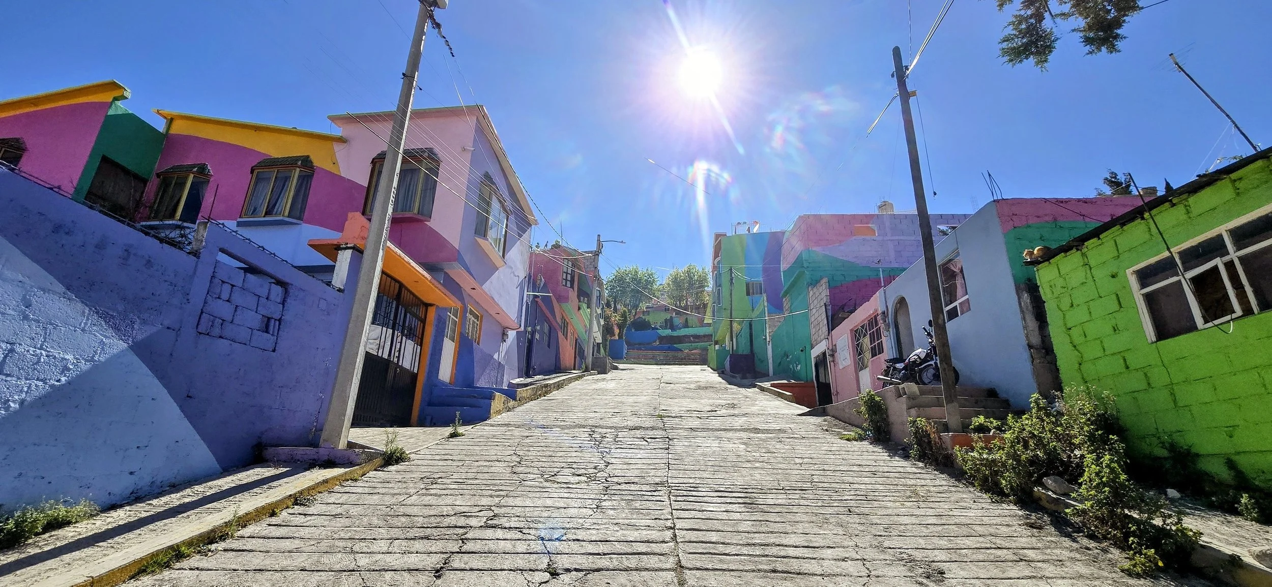
The coolest part about the city by far is the Macromurals de Pachuca. Located in the Palmitas neighborhood, this is one of Mexico's largest murals, covering hundreds of houses in vibrant rainbow patterns. The project, titled "Pachuca Se Pinta" (Pachuca Paints Itself), was a social experiment launched by the Mexican government in 2014 to rehabilitate the Palmitas neighborhood. The primary goal was to reduce youth violence and gang activity by creating jobs and instilling community pride. It's generally safe to walk during the day, but I'd still be careful walking alone, in the evenings, stray dogs, or through narrow alleys. For the most dramatic wide-angle perspective, head to the pedestrian bridge over Rio de las Avenidas and there are some good spots near the Sam's Club parking lot.
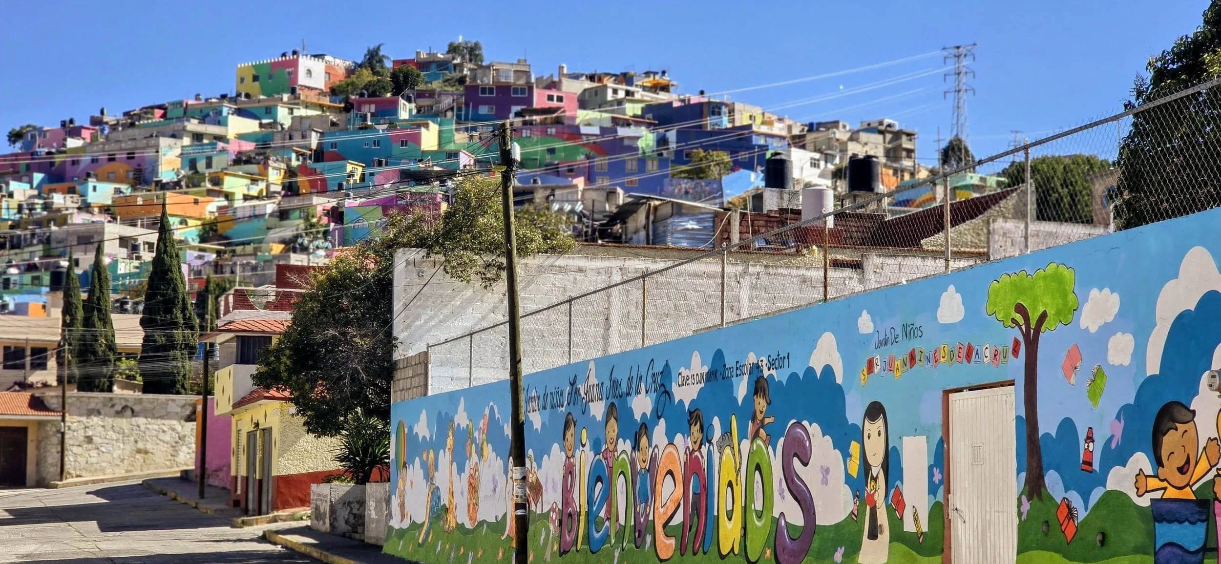
Both of the photos of the steps and the school were taken from within the neighborhood. Walking tours are also available, allowing you to see the details of the individual houses and meet the residents.
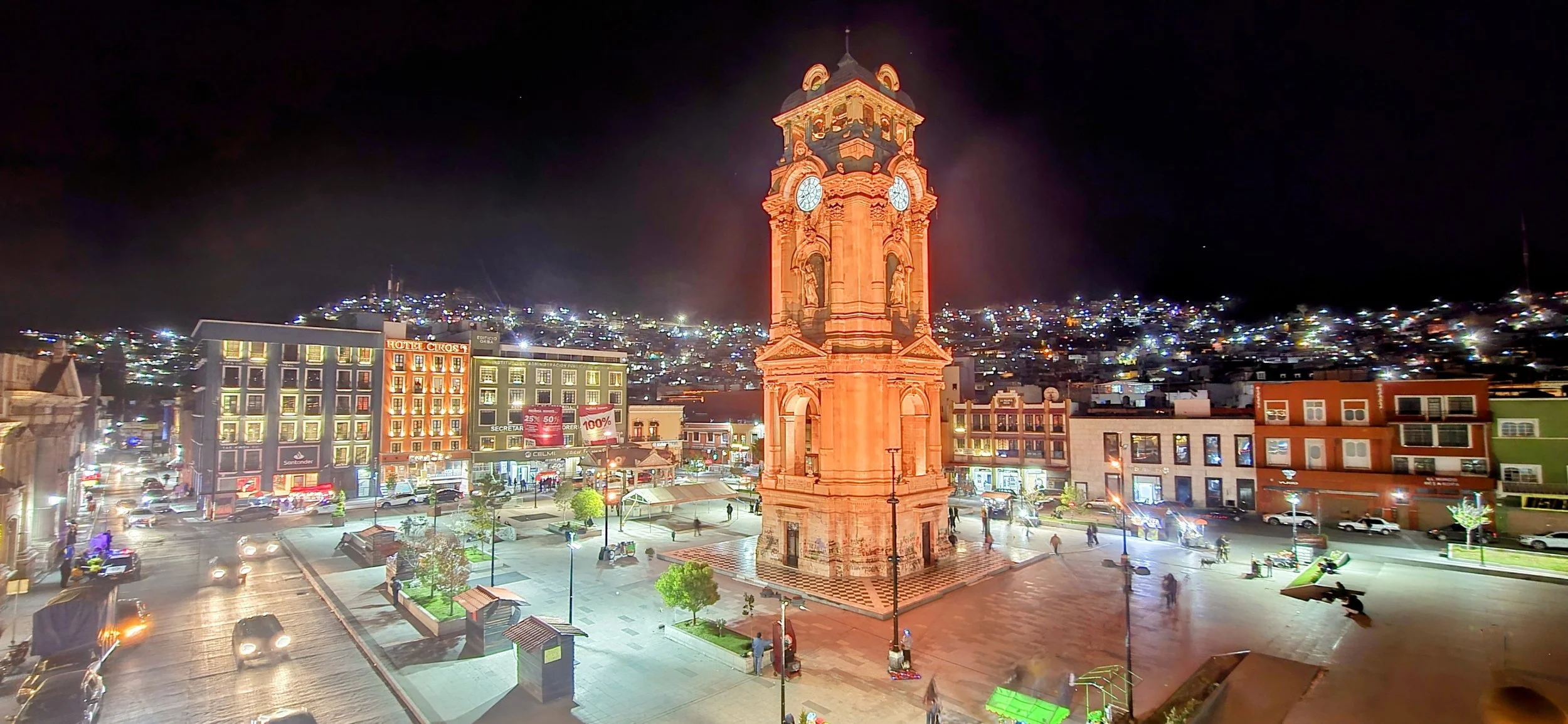
The Reloj Monumental is a 40-meter-tall neoclassical clock tower in Plaza Independencia. It was built with the same machinery as London's Big Ben to commemorate the centennial of Mexican independence. To capture this photo, you'll need to get to the 2nd or 3rd floor of one of the surrounding hotels. Unfortunately, the tower itself is covered in graffiti, which prevents a nice close-up photo. Pachuca's most iconic central market is the Mercado Primero de Mayo, which is also in the historic center and open daily. It serves as a vital hub for local life, fresh food and traditional goods.
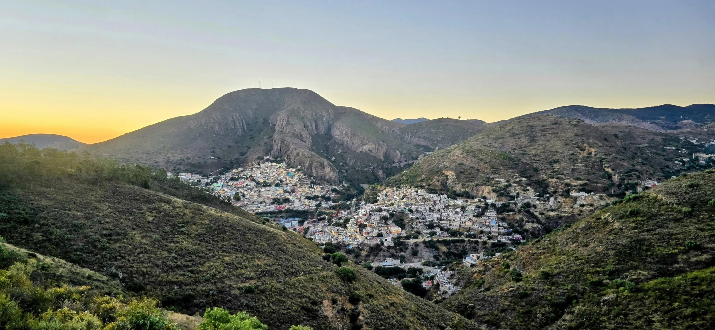
The most famous viewpoint in Pachuca is Cristo Rey, a 33-meter-tall statue of Jesus that overlooks the entire city from the top of the Santa Apolonia hill. It is widely considered the best spot for 360-degree panoramic views of the "Windy City" and surrounding mountains. You can reach the summit by car or taxi departing from the city center. For more exercise, a moderate 1.2-mile trail leads from the city to the base, but I'm unsure of its safety. The site is generally open daily from 7am-5pm, and I believe there is a small fee to climb the stairs inside for an even higher vantage point. Unfortunately, we couldn't visit during normal hours so this is a photo of a nearby village from the same road leading to the entrance of the statue.
Mineral del Chico
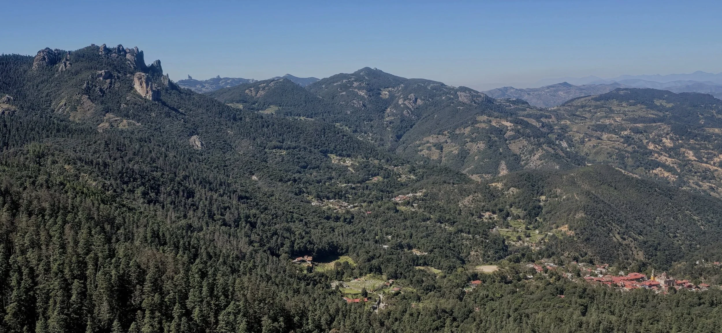
The last destination east of CDMX is Mineral del Chico, a small picturesque mountain town 45 minutes north of Pachuca. The Pueblo Magico is nestled in the Sierra de Pachuca at an elevation of almost 10,000 feet and serves as the gateway to the stunning El Chico National Park. Most visitors spend a day wandering the streets and hiking to Mirador Pena del Cuervo, but you can easily add more time by entering the National Park. This adventure sport hub features activities like Via Ferrata, ziplining, ATVing, and more. To get this photo, you need to either take an off-road vehicle or hike to Mirador Pena del Cuervo. Although fairly easy, the hike takes approximately 45 minutes to the viewpoint and most of the trail has a slight incline. Once at the viewpoint, the panoramic view of the mountains and town is pretty awesome and even more impressive in person. I found the best photo spot to be the far right of the platform; it's even better if you hop the wall which isn't technically allowed but nobody is monitoring.

The small town of Mineral Del Chico consists of only a few streets and is highlighted by the neoclassical church, the Parish of the Immaculate Conception. Other than that, "must-try" items include mixiote (meat cooked in agave parchment) and the enchiladas. This photo overlooking the main square was taken from the Parish steps, and the yellow pole is impossible to miss. As mentioned before, there is much more to do nearby if time permits, including: 1) El Chico National Park; 2) Taking a road trip through the narrow, forested roads; 3) Visiting Real del Monte (Mineral del Monte) located 10-15 minutes away and famous for its Cornish mining heritage; and 4) Seeing Prismas Basalticos (Basaltic Prisms) -- towering geometric basalt columns formed by ancient lava flows, with waterfalls cascading over them (very touristy). If you had to choose one, I would research the National Park more, followed by the road trip.
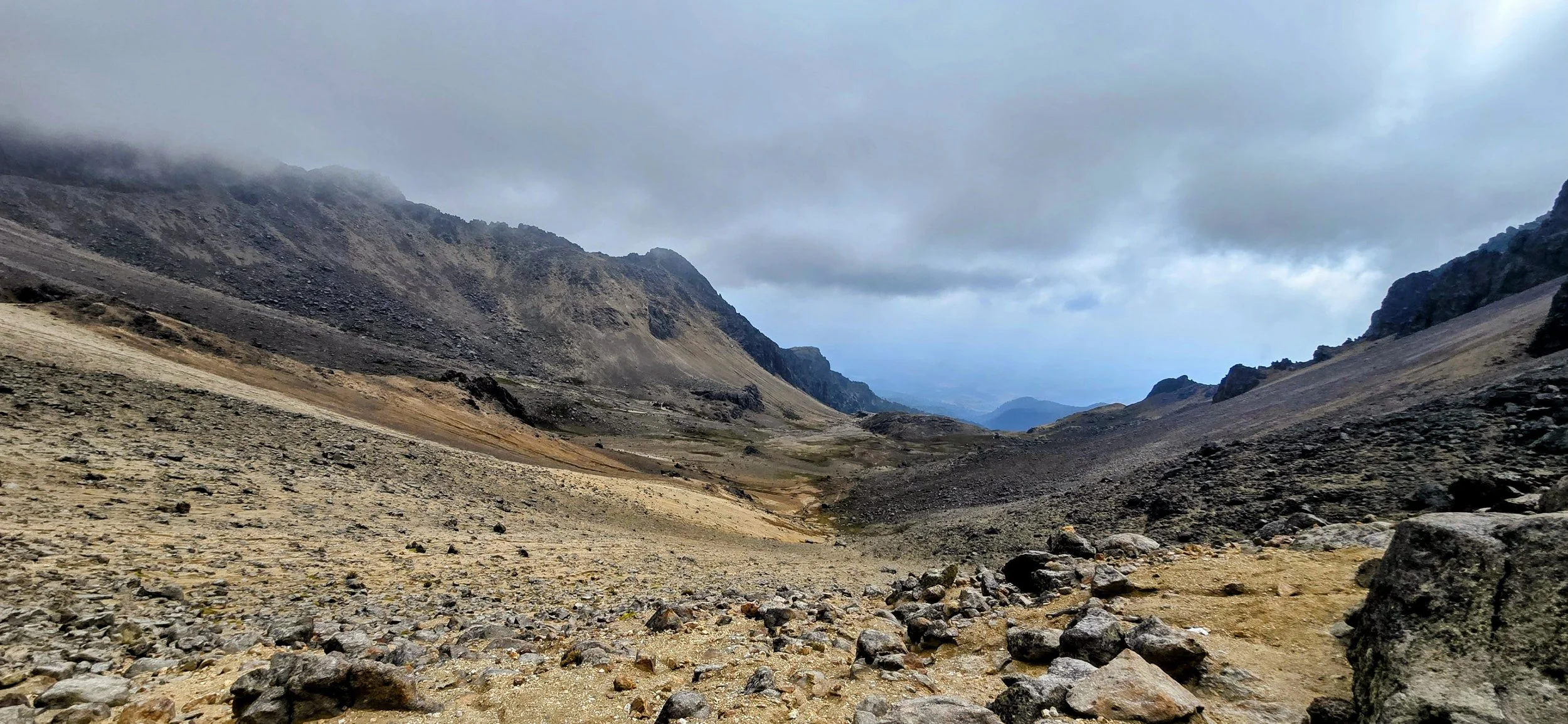
Parque Nacional Iztaccihuatl
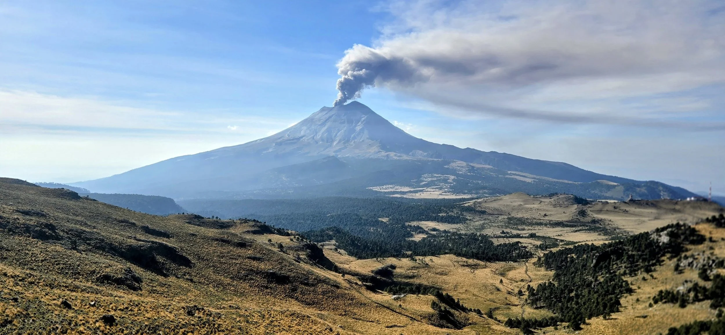
Iztaccihuatl National Park is a premier outdoor destination, featuring the country's second and third-highest volcanoes. Known for its dramatic alpine scenery and challenging hiking trails, the park is a popular day trip adventure for visitors from CDMX or Puebla. However, I recommend leaving from CDMX since it's easier in general. Similar to Nevado de Toluca, this is a "must-do" activity if you enjoy adventure, nature, culture and challenging hikes. I booked a small group tour (3-4 people) for one day via Que Loco Tours and it was fantastic. I did the "Moderate" level tour, but four levels are available, ranging from Easy to Advanced. Since our group moved quickly, we ended up taking the more "Advanced Moderate" route which I recommend for anyone in really good shape. Breathing can be slightly difficult at 12,000- 13,000 feet, but nothing too concerning. The total cost is approximately $140 USD not including tip and the drive from CDMX is roughly two and a half hours. Honestly, you could probably do this hike yourself, but it can become a little dicey at times, so I'd recommend sticking with a guided tour, especially since they provide equipment. This photo of the Popo volcano was taken during the initial ascent of the hike and you can’t miss it.
As you continue to climb, you'll ascend into the clouds and the terrain will dramatically change to resemble another planet. The trail is very narrow in areas with lingering snow and ice, adding a little adrenaline to the adventure, but it's not concerning. I took this photo just after eating lunch on the summit as we began the descent.

The final part of the descent is a bit of a fun obstacle course because there isn't a direct path; it's more of a boulder scramble. Those mountains in the background of this photo are where you're descending from, but the descent isn't nearly as difficult as it looks.
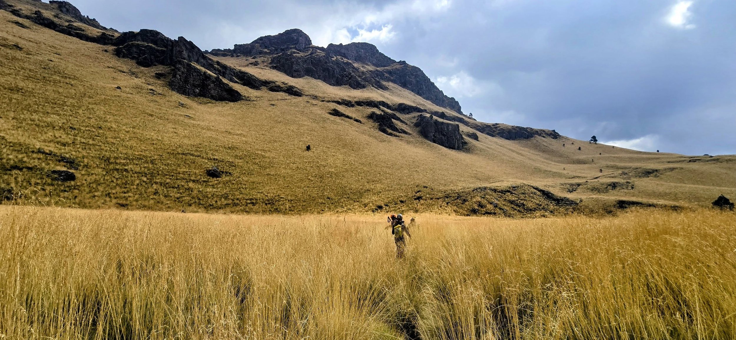
As you head back to the parking lot, you'll continue through the large meadow, which offers stunning views in all directions. You should know that I omitted many great photos to keep this blog readable, but many other landscapes from this trek are not captured here. This is a full day hike so be prepared to arrive at your hotel between 7pm- 10pm depending on the tour length.
Mexico City
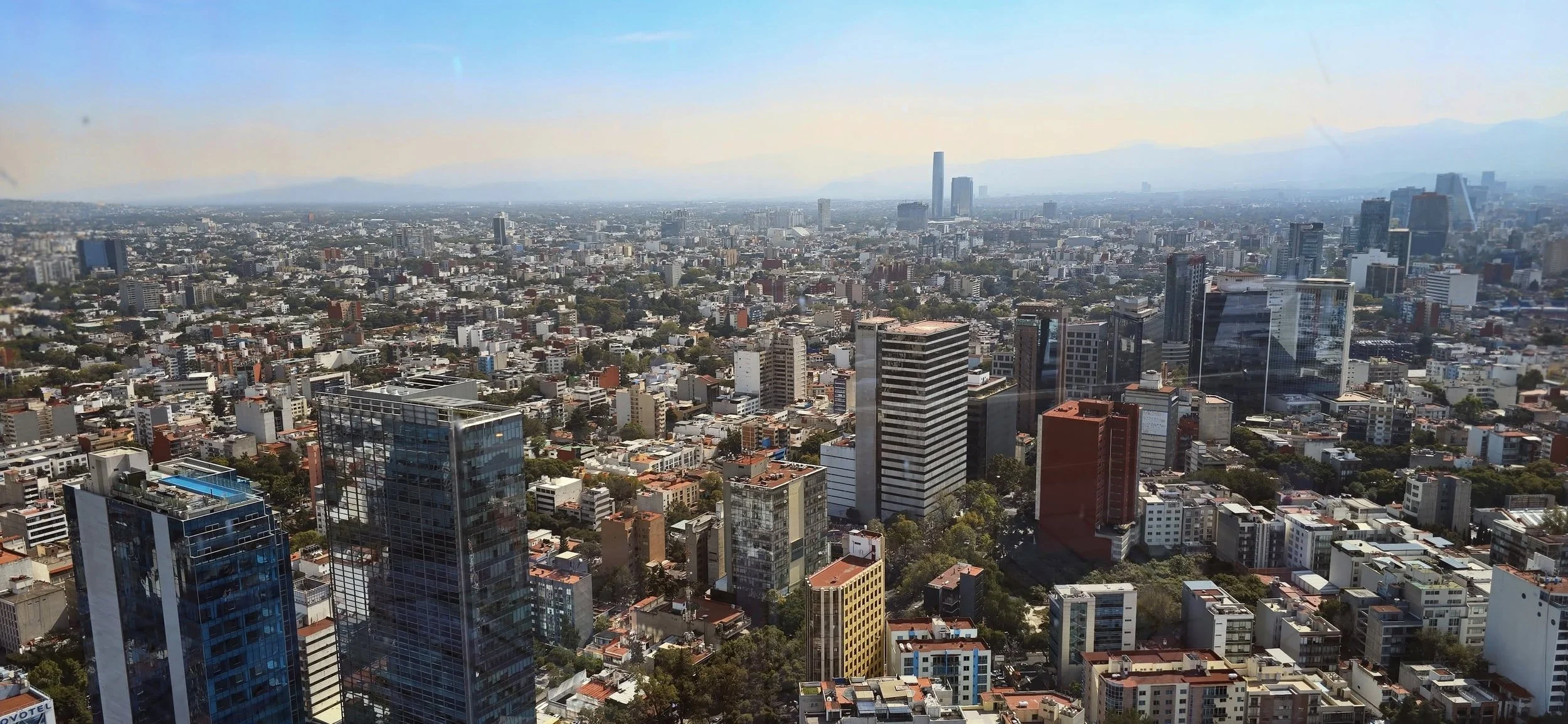
Stating the obvious, Mexico City is gigantic and is considered the most populous city in North America. One could probably spend a month exploring everything CDMX offers, but you could see most of the top attractions in a week. As a reminder, I took limited photos of CDMX because it served as more of a hub for my trip, so exploring a few additional blogs could be helpful. This photo was taken from Bellini, the famous rotating restaurant located on the 45th floor of the World Trade Center. It's renowned as the world's largest revolving restaurant and offers 360-degree panoramic views of the city skyline. The food was decent, but not necessarily worth the money--however, the experience is still worth visiting for. Bellini is only 5 miles from Polanco, but traffic still makes the drive approximately 30 minutes by car. Since there isn't much else to do in the area, perhaps use Bellini as an early evening dinner spot to end one of your nights.
Polanco, Condesa, and Roma are premier Mexico City neighborhoods with distinct vibes: Polanco is an upscale, modern area known for luxury shopping and fine dining; Condesa is a relaxed, leafy, Art Deco neighborhood popular with dog walkers; and Roma is a trendy, bohemian hub known for creative cafes, nightlife, and historic architecture. You can walk all three neighborhoods in two days if you start early in the morning and maintain a consistent pace.
Day 1: Polanco-- The most popular attractions are the Museo Nacional de Antropología, Museo Jumex & Soumaya, Avenida Presidente Masaryk (for shopping) and Chapultepec Park. Museo Antropologia was always packed so arrive early or try to purchase tickets in advance. You could spend the rest of the day wandering Chapultepec park, often described as twice the size of New York's Central Park. Exploring Polanco's neighborhood streets can also keep you busy for hours. Polanco is widely considered the culinary heart of CDMX. The scene is defined by an upscale atmosphere, high-end international cuisines, and a strong presence of Michelin-starred restaurants. You can find more local dishes in Condesa, Roma and the rest of the city.
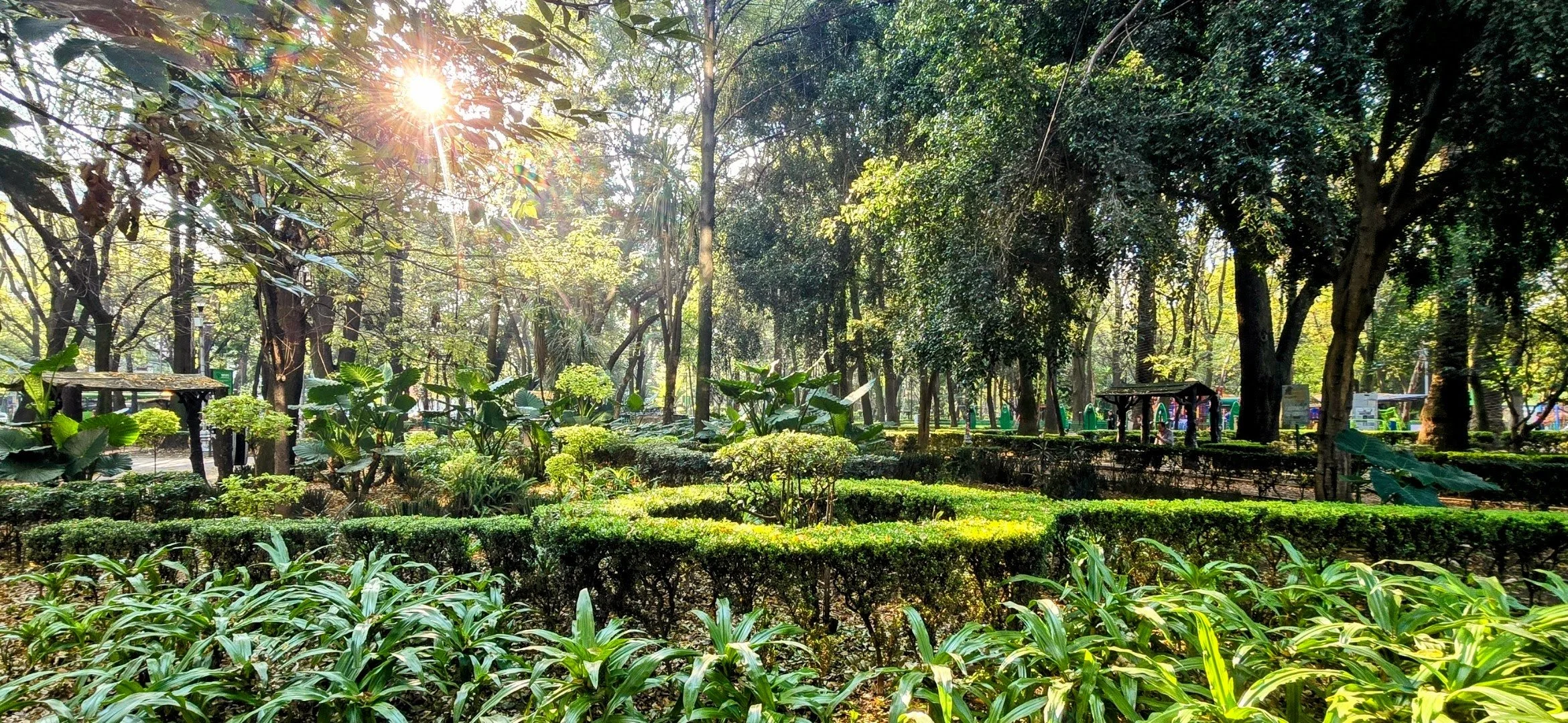
Day 2: Condesa & Roma-- The heart of Condesa is a 22-acre park featuring lush trees, Art Deco monuments like the Foro Lindbergh, and a famous dog training school where you can watch off-leash dogs socialize. There is also a circular, tree-lined pedestrian walkway that follows the path of an old horse racing track, perfect for a scenic jog or stroll past elegant townhouses and hidden cafes--that's where this photo was taken from. Condesa also has one of the city's densest concentrations of specialty coffee shops, restaurants, art galleries and boutique shopping. Overall, I would have a difficult time choosing between Polanco and Condesa if I lived in CDMX. Roma is the vibrant, artistic, and slightly more urban counterpart to Condesa, often called the "Williamsburg of CDMX." It seemed much larger and had a younger demographic compared to Condesa. There are a few different parts of Roma Norte is the most popular area for visitors, packed with the city's trendiest restaurants, bars, and concept stores. Honestly, I wasn't the biggest fan of Roma because it didn't seem like my vibe, but others may love it.
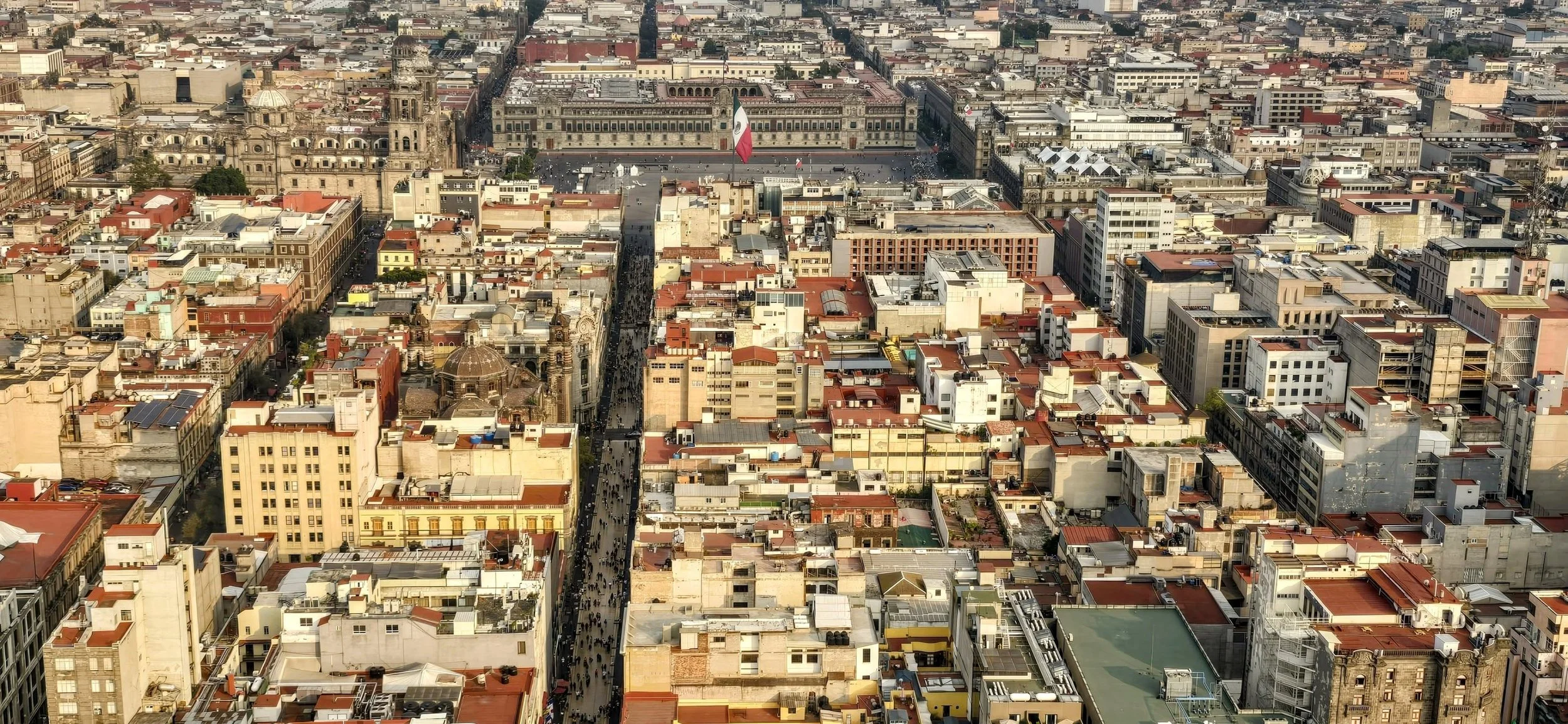
Centro Historico is the "beating heart" of Mexico City and a UNESCO World Heritage Site that compresses 700 years of history into one vibrant, busy district. Built directly over the ruins of the Aztec capital, Tenochtitlan, it features a unique architectural blend where ancient stone foundations support massive colonial cathedrals and 19th-century palaces. Although only 5 miles from Polanco, the trip takes about 30 minutes by Uber due to traffic. I recommend spending half a day wandering the area, but arrive early to avoid large crowds. My top attractions include:
The Zocalo (Plaza de la Constitucion): One of the largest public squares in the world, this massive plaza is the city's political and cultural epicenter, surrounded by the National Palace and the Metropolitan Cathedral.
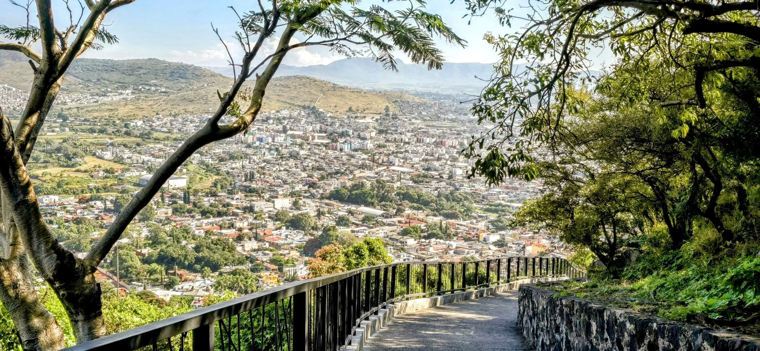
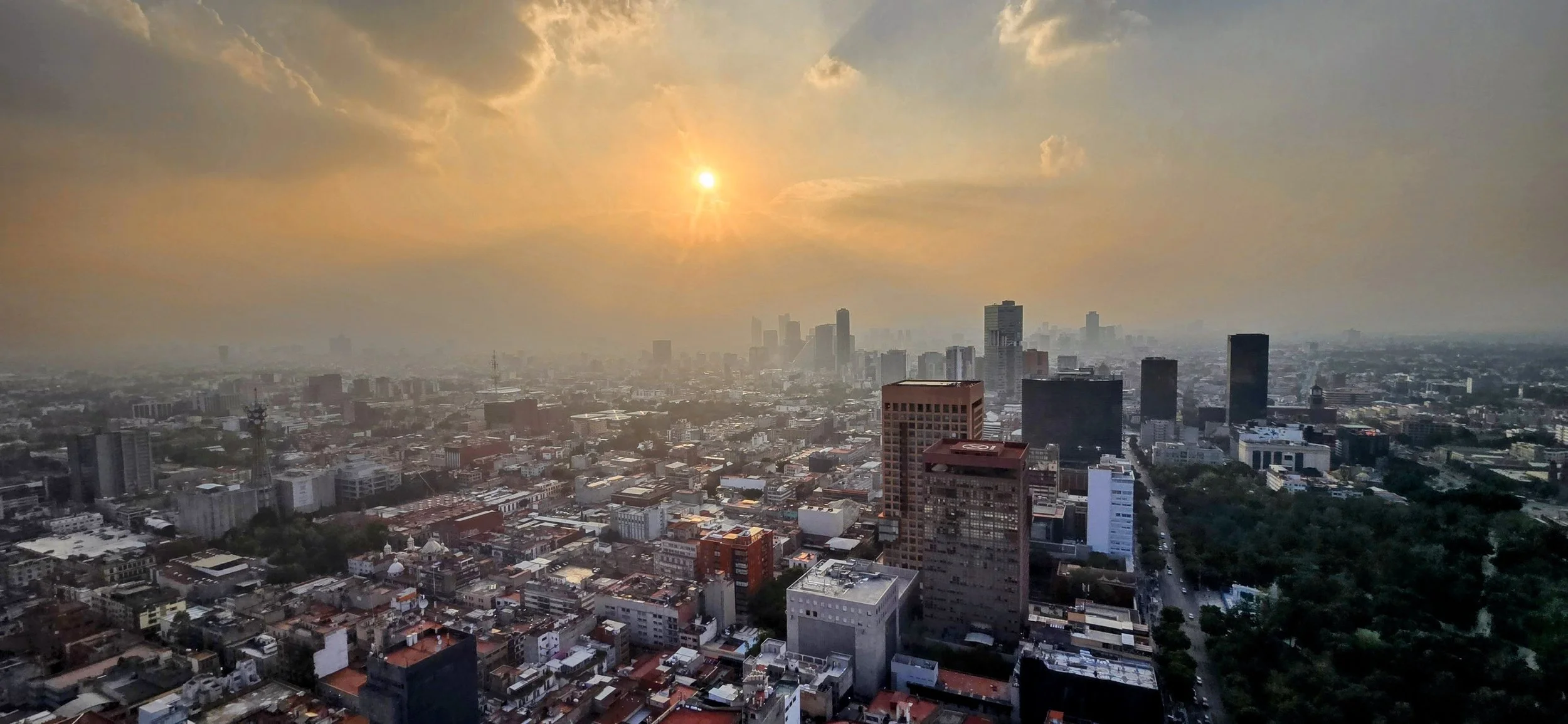
Torre Latinoamericana: My favorite part of the area, this 44-story skyscraper offers panoramic city views. Sunset is best for photos, but it's also the busiest time. The photo at the very top of this blog was taken from this tower as well.
Templo Mayor: Located next to the Zocalo, these excavated ruins represent the Aztecs' most sacred temple, which they believed to be the center of the universe.
Palacio de Bellas Artes: An iconic white marble palace with an Art Deco interior that serves as the city's premier venue for ballet and opera. It also houses Diego Rivera's world-famous murals.
There are tons of markets and shopping stores to explore, but they won't have the premium quality of Polanco. I'd also be a little careful walking too deep into the side streets.
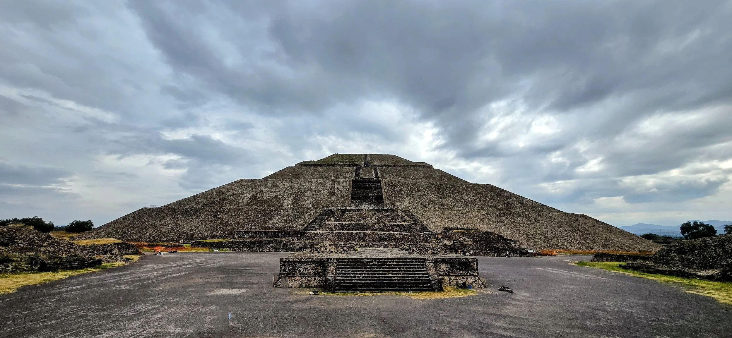
One of the most popular quick day trips (~30 miles) from CDMX is Teotihuacan, an ancient Mesoamerican city, famous for its massive pyramids--most notably the Pyramid of the Sun and the Pyramid of the Moon. There are a ton of organized tours, but I chose to Uber to set my own schedule. Visitors can typically climb parts of the pyramids for panoramic views of the city layout, though certain areas may occasionally be restricted. The entrance fee is approximately $10 and parking is $3 USD. Needless to say, this is an extremely touristy spot so arrive early to avoid large crowds. This photo was taken while looking at the Pyramid of the Sun and I waited about 30 minutes for most of the people to clear.
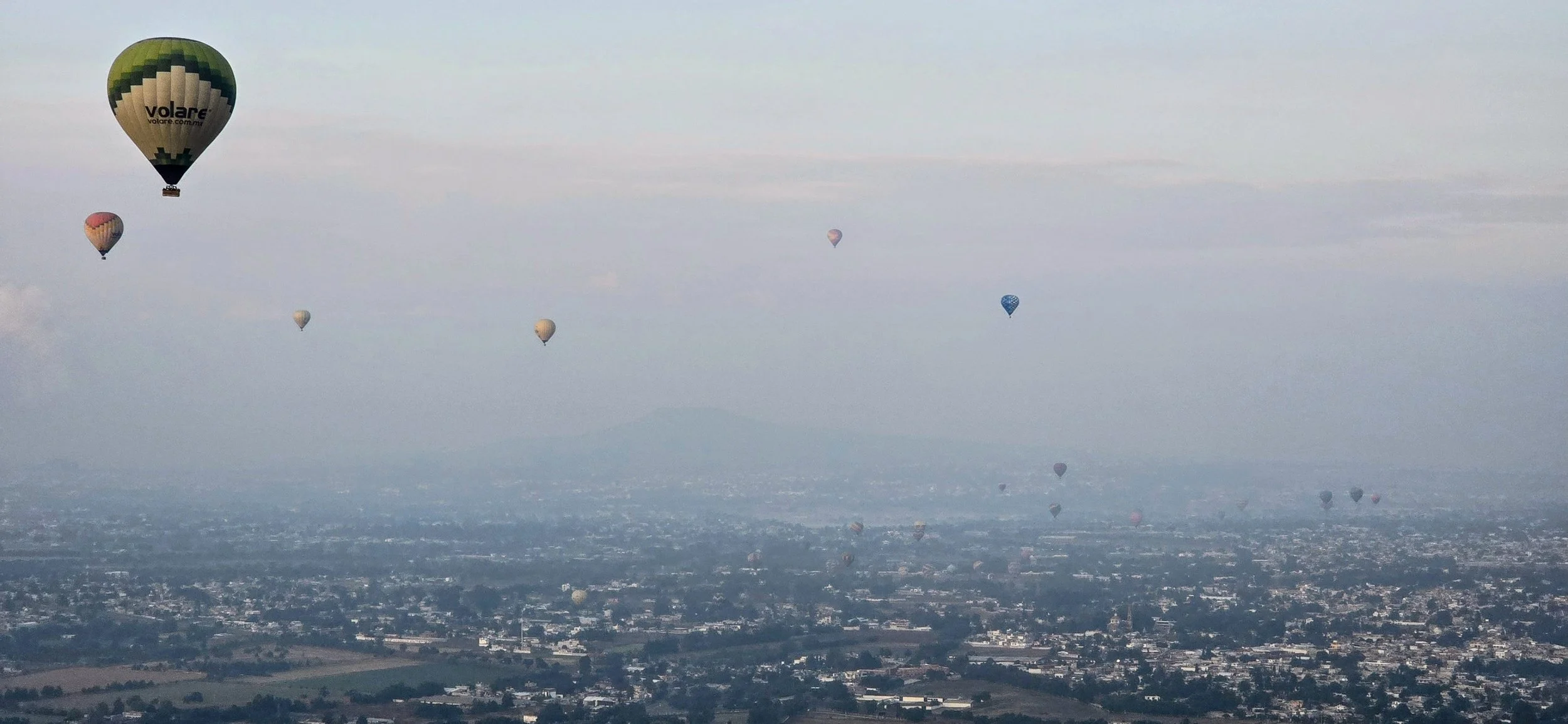
While visiting Teotihuacan, you cannot miss the hot air balloon flight over the pyramids! Both activities should fill one full day. I booked my tour through Viator for approximately $150 USD, but many sites sell the same activity. The balloon ride lasts approximately 30- 50 minutes and you'll split the ride with around 10 others. The views are great from all angles and most people are constantly moving, so don't stress if you're not on the best side to start. That being said, I'm not sure if it's entirely possible, but try to secure one of the last balloons to take off. You'll have many more balloons in view for a photo. Make sure to take photos shortly after departure or many of the balloons will have gone out of sight or landed.
During the flight, fun music will be pumping as you fly over the pyramids and everyone will be in a good mood. The landing is one of the most exciting parts of the ride because you'll whisk just above the tree lines before the pilot decides which random farm to use for landing. You'll then board the rear of a pickup truck as it drives through the farms back to the home base. This video was filmed a few minutes before landing in one of those fields ahead.
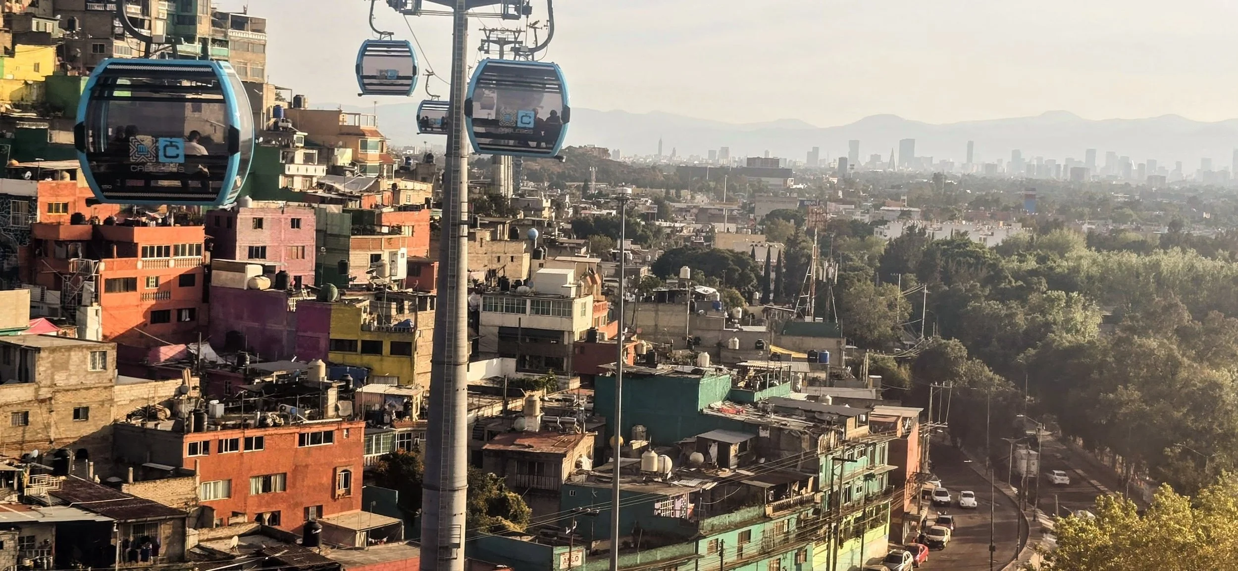
Ecatepec de Morelos is a large city in the State of Mexico, primarily known as a major industrial hub and the most populous suburb of Greater Mexico City. It's approximately a 30 minute drive from Polanco. Ecatepec is home to Mexico's first aerial cable car system used for public transit, built to navigate the city's hilly terrain and high population density. Mexico City has many cable car lines, but in my opinion, the "Mexicable" is the most unique and adventurous. However, exercise caution: visit during daylight hours and consider hiring a private guide who knows the area well, as you will stick out. This isn't the neighborhood for wandering aimlessly, especially at night. This photo, taken a few minutes into the ride, faces Mexico City's skyline.
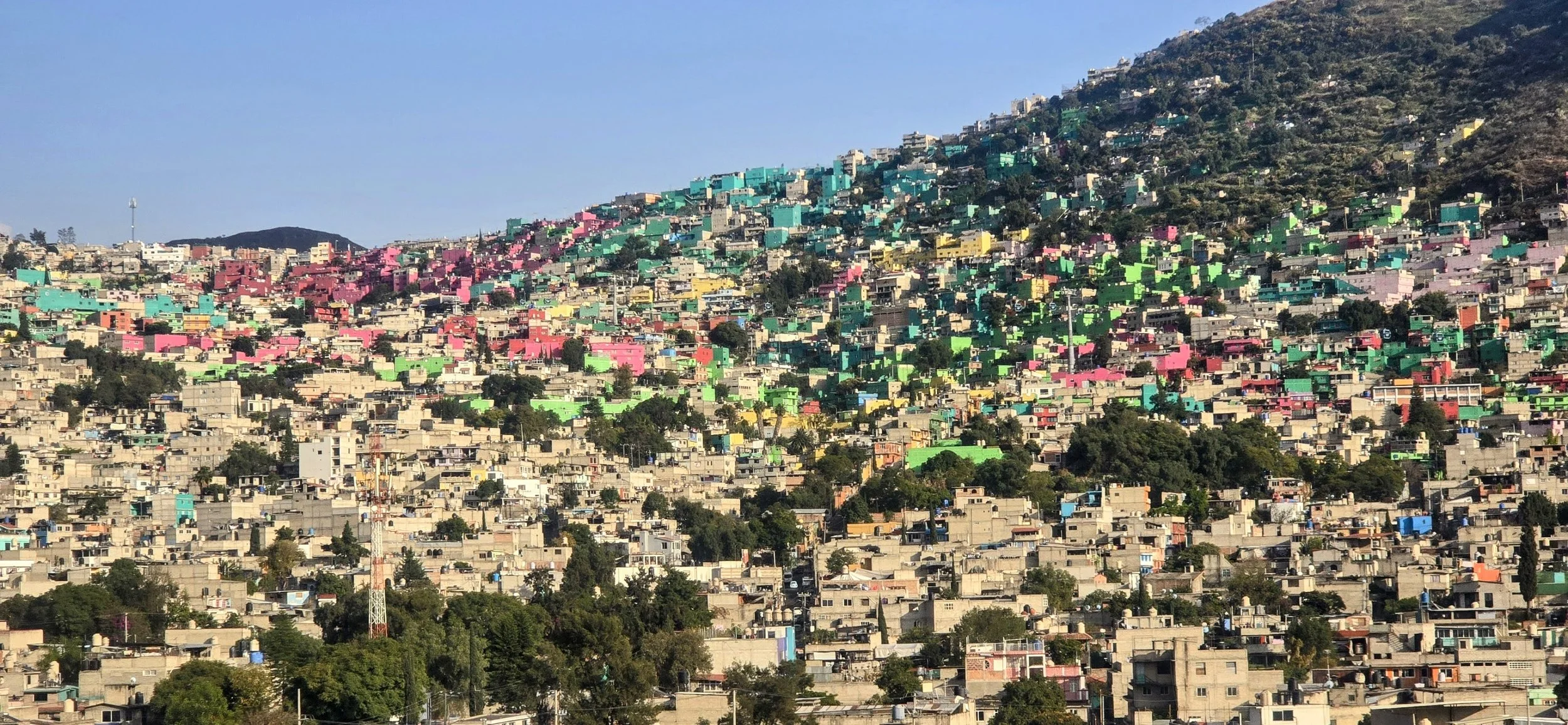
The colorful houses in Ecatepec primarily result from a large-scale urban art project sponsored by the government to revitalize the community (similar to Pachuca). By turning drab concrete hillsides into vibrant landscapes, authorities hope to instill community pride and belonging among residents. The ride through these favelas is one of the coolest cable car experiences in Latin America, at least for me. This photo was taken approximately halfway through the ride facing the macromurals. Taking photos might feel awkward because this isn't considered a tourist destination and most locals are very poor.
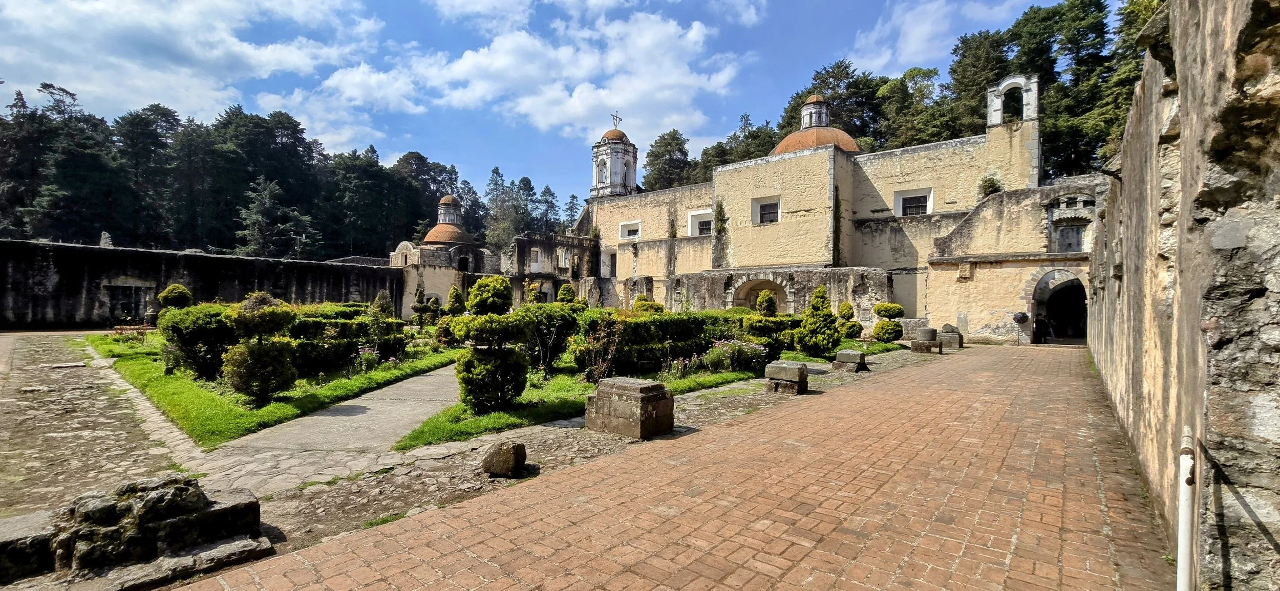
Desierto de los Leones is a high-altitude national park approximately a 30- to 60-minute drive west from CDMX depending on traffic. There is no cable car access and calling an Uber from the park can be difficult. Despite its name, it is neither a desert nor home to lions. The park is typically open Tuesday through Sunday (closed Mondays) and a half a day is all that's needed. While park access is often free or requires a nominal fee, there is a small charge (around 20 pesos) to enter the ex-convent. The park's centerpiece is a 17th-century monastery where visitors can explore its old cells, gardens and a network of dark, underground tunnels. The park is a premier destination for hiking and mountain biking. The most popular trail is Cerro San Miguel, the highest peak in the park, which offers expansive views of the valley of Mexico. Numerous food stalls near the entrance serve traditional Mexican dishes, most notably blue corn quesadillas and pulque. While we didn't have time to hike, we visited the monastery and had lunch at a Fonda (a small family restaurant), which was a nice time. I took this photo from the main monastery's garden and had to wait a while for the area to clear of tourists.
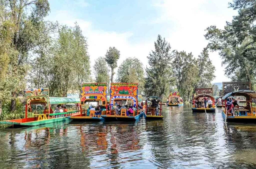
Xochimilco is a historic borough located about 15 miles south of Mexico City's center. Known as the "Venice of Mexico," it is famous for its extensive network of ancient canals and colorful, flat-bottomed boats called trajineras. The atmosphere is often a "floating fiesta" with mariachi bands, food vendors in small canoes and partiers. We went during the Day of the Dead and it was packed with a younger crowd. There is also the Island of the Dolls (Isla de las Muñecas), a world-famous "dark tourism" site where hundreds of old, decaying dolls hang from the trees. According to legend, the island's former owner hung them to appease the spirit of a girl who drowned nearby. Keep the following in mind: 1) Go on Sundays for the full party experience. 2) The most common way to get there is by Metro Line 2 because Uber rides can often take an hour and a half. 3) Boat rentals are approximately $30 per hour. 4) Make sure to bring cash for boat fees, food and restroom access since most of the area doesn't accept credit cards or the signal might be bad. Overall, this is a nice place to end your weekend. I lost these photos so I transparently borrowed a similar one from the web.
Overall, Mexico City and its neighboring towns were a fantastic experience and much safer than the news suggests. Again, a special shoutout goes to my Mexican Spanish tutor, Erick Fabila, for helping me plan this trip. This concludes Part 1 of my Mexico blog and I hope you join me in Part 2 where I cover a few of the more adventurous regions in the country.